You are here: Home > Network List > GE - GEOFON Stations List
> Station PSZ GKKI/GEOFON Station Piszkes, Hungary > Earthquake Result Viewer
PSZ GKKI/GEOFON Station Piszkes, Hungary - Earthquake Result Viewer
| Earthquake location: |
Kuril Islands |
| Earthquake latitude/longitude: |
43.9/146.1 |
| Earthquake time(UTC): |
2005/09/21 (264) 02:25:08 GMT |
| Earthquake Depth: |
103 km |
| Earthquake Magnitude: |
6.0 MB, 6.1 MW, 6.0 MW |
| Earthquake Catalog/Contributor: |
WHDF/NEIC |
|
| Network: |
GE GEOFON |
| Station: |
PSZ GKKI/GEOFON Station Piszkes, Hungary |
| Lat/Lon: |
47.92 N/19.89 E |
| Elevation: |
940 m |
|
| Distance: |
77.1 deg |
| Az: |
326.182 deg |
| Baz: |
36.74 deg |
| Ray Param: |
0.05032896 |
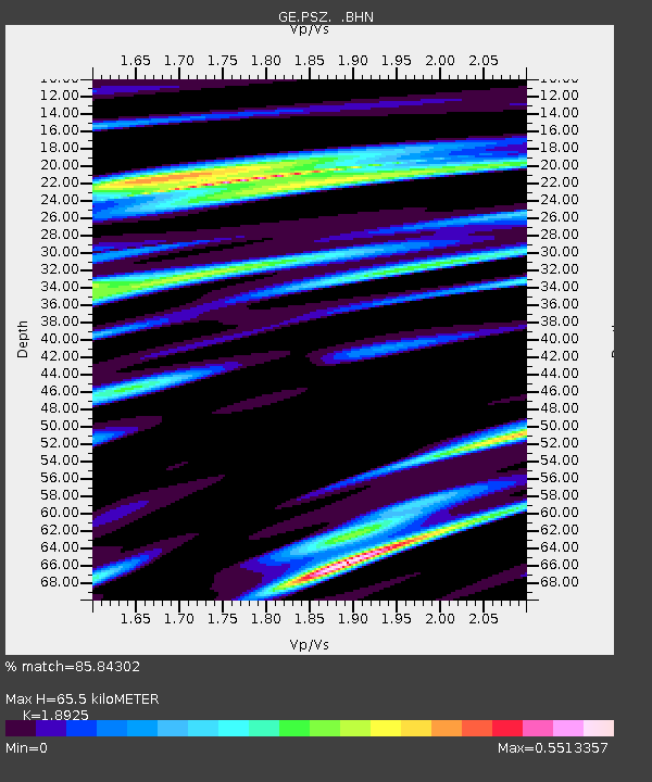
| Estimated Moho Depth: |
65.5 km |
| Estimated Crust Vp/Vs: |
1.89 |
| Assumed Crust Vp: |
6.155 km/s |
| Estimated Crust Vs: |
3.252 km/s |
| Estimated Crust Poisson's Ratio: |
0.31 |
|
| Radial Match: |
85.84302 % |
| Radial Bump: |
387 |
| Transverse Match: |
77.06119 % |
| Transverse Bump: |
400 |
| SOD ConfigId: |
2475 |
| Insert Time: |
2010-03-09 04:03:47.567 +0000 |
| GWidth: |
2.5 |
| Max Bumps: |
400 |
| Tol: |
0.001 |
|

Signal To Noise
| Channel | StoN | STA | LTA |
| GE:PSZ: :BHN:20050921T02:36:19.094009Z | 7.667577 | 1.0905122E-6 | 1.4222384E-7 |
| GE:PSZ: :BHE:20050921T02:36:19.094009Z | 5.934956 | 1.0594113E-6 | 1.7850364E-7 |
| GE:PSZ: :BHZ:20050921T02:36:19.094009Z | 23.302269 | 3.4582176E-6 | 1.484069E-7 |
| Arrivals |
| Ps | 9.8 SECOND |
| PpPs | 30 SECOND |
| PsPs/PpSs | 40 SECOND |


