You are here: Home > Network List > CI - Caltech Regional Seismic Network Stations List
> Station MPM Manuel Prospect Mine, California, USA > Earthquake Result Viewer
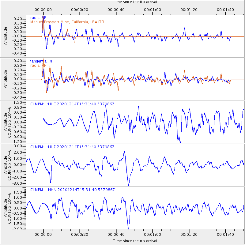
MPM Manuel Prospect Mine, California, USA - Earthquake Result Viewer
*The percent match for this event was below the threshold and hence no stack was calculated.
| Earthquake location: |
Chile-Bolivia Border Region |
| Earthquake latitude/longitude: |
-21.8/-68.7 |
| Earthquake time(UTC): |
2020/12/14 (349) 15:20:49 GMT |
| Earthquake Depth: |
111 km |
| Earthquake Magnitude: |
6.0 Mww |
| Earthquake Catalog/Contributor: |
NEIC PDE/us |
|
| Network: |
CI Caltech Regional Seismic Network |
| Station: |
MPM Manuel Prospect Mine, California, USA |
| Lat/Lon: |
36.06 N/117.49 W |
| Elevation: |
185 m |
|
| Distance: |
73.8 deg |
| Az: |
320.584 deg |
| Baz: |
133.266 deg |
| Ray Param: |
$rayparam |
*The percent match for this event was below the threshold and hence was not used in the summary stack. |
|
| Radial Match: |
64.648026 % |
| Radial Bump: |
400 |
| Transverse Match: |
61.42743 % |
| Transverse Bump: |
400 |
| SOD ConfigId: |
23341671 |
| Insert Time: |
2020-12-28 16:25:38.827 +0000 |
| GWidth: |
2.5 |
| Max Bumps: |
400 |
| Tol: |
0.001 |
|
Signal To Noise
| Channel | StoN | STA | LTA |
| CI:MPM: :HHZ:20201214T15:31:40.537986Z | 2.4226456 | 1.1686184E-6 | 4.8237285E-7 |
| CI:MPM: :HHN:20201214T15:31:40.537986Z | 1.1036851 | 4.7349377E-7 | 4.2901164E-7 |
| CI:MPM: :HHE:20201214T15:31:40.537986Z | 2.5732918 | 5.628405E-7 | 2.1872394E-7 |
| Arrivals |
| Ps | |
| PpPs | |
| PsPs/PpSs | |


