You are here: Home > Network List > GS - US Geological Survey Networks Stations List
> Station ASA1 ASA1 > Earthquake Result Viewer
ASA1 ASA1 - Earthquake Result Viewer
| Earthquake location: |
Chile-Bolivia Border Region |
| Earthquake latitude/longitude: |
-21.8/-68.7 |
| Earthquake time(UTC): |
2020/12/14 (349) 15:20:49 GMT |
| Earthquake Depth: |
111 km |
| Earthquake Magnitude: |
6.0 Mww |
| Earthquake Catalog/Contributor: |
NEIC PDE/us |
|
| Network: |
GS US Geological Survey Networks |
| Station: |
ASA1 ASA1 |
| Lat/Lon: |
34.95 N/106.46 W |
| Elevation: |
1829 m |
|
| Distance: |
66.9 deg |
| Az: |
326.832 deg |
| Baz: |
141.766 deg |
| Ray Param: |
0.05704728 |
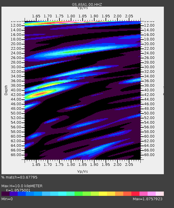
| Estimated Moho Depth: |
10.0 km |
| Estimated Crust Vp/Vs: |
1.86 |
| Assumed Crust Vp: |
6.502 km/s |
| Estimated Crust Vs: |
3.5 km/s |
| Estimated Crust Poisson's Ratio: |
0.30 |
|
| Radial Match: |
83.67795 % |
| Radial Bump: |
400 |
| Transverse Match: |
66.44205 % |
| Transverse Bump: |
379 |
| SOD ConfigId: |
23341671 |
| Insert Time: |
2020-12-28 16:29:41.517 +0000 |
| GWidth: |
2.5 |
| Max Bumps: |
400 |
| Tol: |
0.001 |
|

Signal To Noise
| Channel | StoN | STA | LTA |
| GS:ASA1:00:HHZ:20201214T15:30:58.669028Z | 6.0937386 | 1.7091545E-6 | 2.8047714E-7 |
| GS:ASA1:00:HH1:20201214T15:30:58.669028Z | 3.753597 | 8.0894256E-7 | 2.155113E-7 |
| GS:ASA1:00:HH2:20201214T15:30:58.669028Z | 4.2773404 | 5.622552E-7 | 1.3144972E-7 |
| Arrivals |
| Ps | 1.4 SECOND |
| PpPs | 4.2 SECOND |
| PsPs/PpSs | 5.6 SECOND |


