You are here: Home > Network List > XC91 - Tibetan Plateau Broadband Experiment Stations List
> Station WNDO XC.WNDO > Earthquake Result Viewer
WNDO XC.WNDO - Earthquake Result Viewer

| Earthquake location: |
Southern Sumatra, Indonesia |
| Earthquake latitude/longitude: |
-5.4/103.0 |
| Earthquake time(UTC): |
1992/06/24 (176) 12:27:11 GMT |
| Earthquake Depth: |
48 km |
| Earthquake Magnitude: |
5.3 MB, 5.6 MS |
| Earthquake Catalog/Contributor: |
WHDF/NEIC |
|
| Network: |
XC Tibetan Plateau Broadband Experiment |
| Station: |
WNDO XC.WNDO |
| Lat/Lon: |
33.45 N/91.90 E |
| Elevation: |
4865 m |
|
| Distance: |
40.0 deg |
| Az: |
345.485 deg |
| Baz: |
162.634 deg |
| Ray Param: |
0.07452318 |
| Estimated Moho Depth: |
54.25 km |
| Estimated Crust Vp/Vs: |
1.76 |
| Assumed Crust Vp: |
6.5 km/s |
| Estimated Crust Vs: |
3.688 km/s |
| Estimated Crust Poisson's Ratio: |
0.26 |
|
| Radial Match: |
83.51746 % |
| Radial Bump: |
400 |
| Transverse Match: |
71.472916 % |
| Transverse Bump: |
400 |
| SOD ConfigId: |
23496 |
| Insert Time: |
2010-02-26 15:12:57.938 +0000 |
| GWidth: |
2.5 |
| Max Bumps: |
400 |
| Tol: |
0.001 |
|
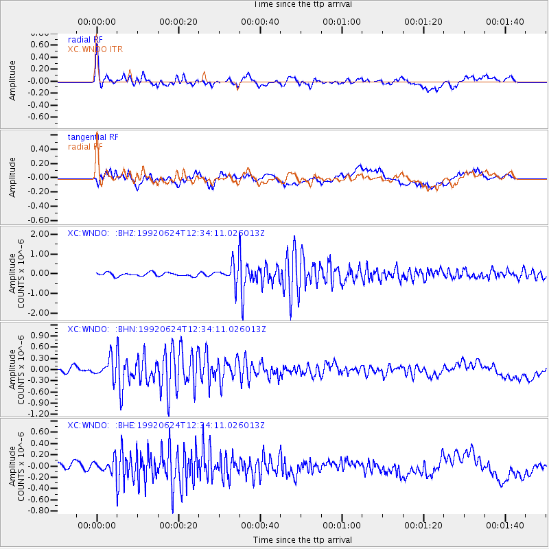
Signal To Noise
| Channel | StoN | STA | LTA |
| XC:WNDO: :BHN:19920624T12:34:11.026013Z | 3.6289372 | 2.7099097E-7 | 7.4675015E-8 |
| XC:WNDO: :BHE:19920624T12:34:11.026013Z | 1.3905249 | 1.18504914E-7 | 8.522316E-8 |
| XC:WNDO: :BHZ:19920624T12:34:11.026013Z | 6.128393 | 5.329425E-7 | 8.696285E-8 |
| Arrivals |
| Ps | 6.8 SECOND |
| PpPs | 21 SECOND |
| PsPs/PpSs | 28 SECOND |


