You are here: Home > Network List > GE - GEOFON Stations List
> Station SANT GEOFON Station Santorini, Greece > Earthquake Result Viewer
SANT GEOFON Station Santorini, Greece - Earthquake Result Viewer
| Earthquake location: |
Mozambique |
| Earthquake latitude/longitude: |
-21.3/33.6 |
| Earthquake time(UTC): |
2006/02/22 (053) 22:19:07 GMT |
| Earthquake Depth: |
11 km |
| Earthquake Magnitude: |
6.5 MB, 7.5 MS, 7.0 MW, 7.0 MW |
| Earthquake Catalog/Contributor: |
WHDF/NEIC |
|
| Network: |
GE GEOFON |
| Station: |
SANT GEOFON Station Santorini, Greece |
| Lat/Lon: |
36.37 N/25.46 E |
| Elevation: |
540 m |
|
| Distance: |
57.9 deg |
| Az: |
352.262 deg |
| Baz: |
171.052 deg |
| Ray Param: |
0.06319702 |
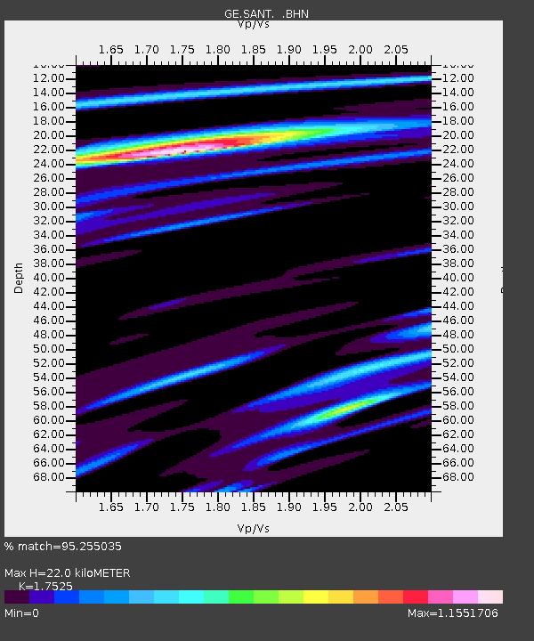
| Estimated Moho Depth: |
22.0 km |
| Estimated Crust Vp/Vs: |
1.75 |
| Assumed Crust Vp: |
5.738 km/s |
| Estimated Crust Vs: |
3.274 km/s |
| Estimated Crust Poisson's Ratio: |
0.26 |
|
| Radial Match: |
95.255035 % |
| Radial Bump: |
392 |
| Transverse Match: |
84.461754 % |
| Transverse Bump: |
400 |
| SOD ConfigId: |
2422 |
| Insert Time: |
2010-03-09 04:04:59.122 +0000 |
| GWidth: |
2.5 |
| Max Bumps: |
400 |
| Tol: |
0.001 |
|

Signal To Noise
| Channel | StoN | STA | LTA |
| GE:SANT: :BHN:20060222T22:28:28.57301Z | 14.771979 | 1.8560232E-6 | 1.2564486E-7 |
| GE:SANT: :BHE:20060222T22:28:28.57301Z | 4.850596 | 8.250169E-7 | 1.7008568E-7 |
| GE:SANT: :BHZ:20060222T22:28:28.57301Z | 49.753174 | 3.8127394E-6 | 7.6633086E-8 |
| Arrivals |
| Ps | 3.0 SECOND |
| PpPs | 10 SECOND |
| PsPs/PpSs | 13 SECOND |


