You are here: Home > Network List > N4 - Central and EAstern US Network Stations List
> Station S39B Bolivar, MO, USA > Earthquake Result Viewer
S39B Bolivar, MO, USA - Earthquake Result Viewer
| Earthquake location: |
Chile-Bolivia Border Region |
| Earthquake latitude/longitude: |
-21.8/-68.7 |
| Earthquake time(UTC): |
2020/12/14 (349) 15:20:49 GMT |
| Earthquake Depth: |
111 km |
| Earthquake Magnitude: |
6.0 Mww |
| Earthquake Catalog/Contributor: |
NEIC PDE/us |
|
| Network: |
N4 Central and EAstern US Network |
| Station: |
S39B Bolivar, MO, USA |
| Lat/Lon: |
37.69 N/93.32 W |
| Elevation: |
340 m |
|
| Distance: |
63.6 deg |
| Az: |
338.333 deg |
| Baz: |
154.374 deg |
| Ray Param: |
0.05919238 |
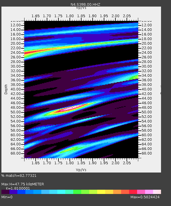
| Estimated Moho Depth: |
47.75 km |
| Estimated Crust Vp/Vs: |
1.81 |
| Assumed Crust Vp: |
6.53 km/s |
| Estimated Crust Vs: |
3.608 km/s |
| Estimated Crust Poisson's Ratio: |
0.28 |
|
| Radial Match: |
82.77321 % |
| Radial Bump: |
353 |
| Transverse Match: |
47.152805 % |
| Transverse Bump: |
299 |
| SOD ConfigId: |
23341671 |
| Insert Time: |
2020-12-28 16:33:53.783 +0000 |
| GWidth: |
2.5 |
| Max Bumps: |
400 |
| Tol: |
0.001 |
|

Signal To Noise
| Channel | StoN | STA | LTA |
| N4:S39B:00:HHZ:20201214T15:30:37.380027Z | 7.799605 | 1.5606781E-6 | 2.0009709E-7 |
| N4:S39B:00:HH1:20201214T15:30:37.380027Z | 4.369219 | 5.863944E-7 | 1.3421035E-7 |
| N4:S39B:00:HH2:20201214T15:30:37.380027Z | 1.7896645 | 4.0915242E-7 | 2.2861963E-7 |
| Arrivals |
| Ps | 6.2 SECOND |
| PpPs | 20 SECOND |
| PsPs/PpSs | 26 SECOND |


