You are here: Home > Network List > GE - GEOFON Stations List
> Station SANT GEOFON Station Santorini, Greece > Earthquake Result Viewer
SANT GEOFON Station Santorini, Greece - Earthquake Result Viewer
| Earthquake location: |
Eastern Siberia, Russia |
| Earthquake latitude/longitude: |
60.5/167.5 |
| Earthquake time(UTC): |
2006/04/29 (119) 16:58:06 GMT |
| Earthquake Depth: |
11 km |
| Earthquake Magnitude: |
6.4 MB, 6.6 MS, 6.6 MW, 6.4 MW |
| Earthquake Catalog/Contributor: |
WHDF/NEIC |
|
| Network: |
GE GEOFON |
| Station: |
SANT GEOFON Station Santorini, Greece |
| Lat/Lon: |
36.37 N/25.46 E |
| Elevation: |
540 m |
|
| Distance: |
78.6 deg |
| Az: |
329.584 deg |
| Baz: |
18.092 deg |
| Ray Param: |
0.049538597 |
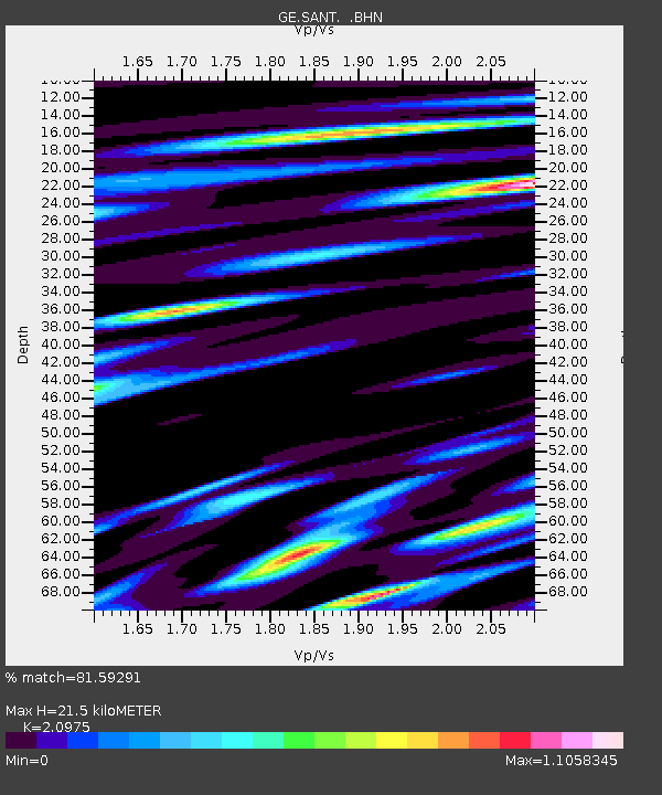
| Estimated Moho Depth: |
21.5 km |
| Estimated Crust Vp/Vs: |
2.10 |
| Assumed Crust Vp: |
5.738 km/s |
| Estimated Crust Vs: |
2.736 km/s |
| Estimated Crust Poisson's Ratio: |
0.35 |
|
| Radial Match: |
81.59291 % |
| Radial Bump: |
400 |
| Transverse Match: |
67.45672 % |
| Transverse Bump: |
400 |
| SOD ConfigId: |
2669 |
| Insert Time: |
2010-03-09 04:05:02.485 +0000 |
| GWidth: |
2.5 |
| Max Bumps: |
400 |
| Tol: |
0.001 |
|

Signal To Noise
| Channel | StoN | STA | LTA |
| GE:SANT: :BHN:20060429T17:09:36.523003Z | 2.5003426 | 6.903203E-7 | 2.7609028E-7 |
| GE:SANT: :BHE:20060429T17:09:36.523003Z | 1.4900323 | 4.1250235E-7 | 2.768412E-7 |
| GE:SANT: :BHZ:20060429T17:09:36.523003Z | 15.069075 | 2.5560707E-6 | 1.696236E-7 |
| Arrivals |
| Ps | 4.2 SECOND |
| PpPs | 11 SECOND |
| PsPs/PpSs | 16 SECOND |


