You are here: Home > Network List > GE - GEOFON Stations List
> Station SANT GEOFON Station Santorini, Greece > Earthquake Result Viewer
SANT GEOFON Station Santorini, Greece - Earthquake Result Viewer
| Earthquake location: |
South Indian Ocean |
| Earthquake latitude/longitude: |
-13.8/97.5 |
| Earthquake time(UTC): |
2000/06/18 (170) 14:44:13 GMT |
| Earthquake Depth: |
10 km |
| Earthquake Magnitude: |
6.8 MB, 7.8 MS, 7.8 MW, 7.6 MW |
| Earthquake Catalog/Contributor: |
WHDF/NEIC |
|
| Network: |
GE GEOFON |
| Station: |
SANT GEOFON Station Santorini, Greece |
| Lat/Lon: |
36.37 N/25.46 E |
| Elevation: |
540 m |
|
| Distance: |
84.1 deg |
| Az: |
309.501 deg |
| Baz: |
111.752 deg |
| Ray Param: |
0.045704074 |
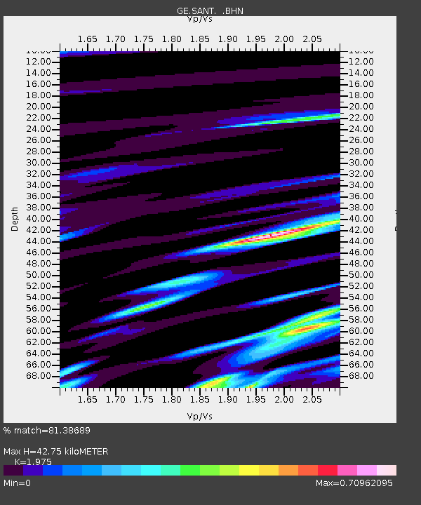
| Estimated Moho Depth: |
42.75 km |
| Estimated Crust Vp/Vs: |
1.98 |
| Assumed Crust Vp: |
5.738 km/s |
| Estimated Crust Vs: |
2.905 km/s |
| Estimated Crust Poisson's Ratio: |
0.33 |
|
| Radial Match: |
81.38689 % |
| Radial Bump: |
400 |
| Transverse Match: |
84.068535 % |
| Transverse Bump: |
400 |
| SOD ConfigId: |
3744 |
| Insert Time: |
2010-03-09 04:05:05.263 +0000 |
| GWidth: |
2.5 |
| Max Bumps: |
400 |
| Tol: |
0.001 |
|

Signal To Noise
| Channel | StoN | STA | LTA |
| GE:SANT: :BHN:20000618T14:56:12.895022Z | 1.6724057 | 4.8178526E-6 | 2.8807917E-6 |
| GE:SANT: :BHE:20000618T14:56:12.895022Z | 1.6089792 | 5.4265533E-6 | 3.3726685E-6 |
| GE:SANT: :BHZ:20000618T14:56:12.895022Z | 4.744895 | 3.7996992E-6 | 8.007973E-7 |
| Arrivals |
| Ps | 7.4 SECOND |
| PpPs | 22 SECOND |
| PsPs/PpSs | 29 SECOND |


