You are here: Home > Network List > N4 - Central and EAstern US Network Stations List
> Station V55A Morning Dew, Taylorsville, NC, USA > Earthquake Result Viewer
V55A Morning Dew, Taylorsville, NC, USA - Earthquake Result Viewer
| Earthquake location: |
Chile-Bolivia Border Region |
| Earthquake latitude/longitude: |
-21.8/-68.7 |
| Earthquake time(UTC): |
2020/12/14 (349) 15:20:49 GMT |
| Earthquake Depth: |
111 km |
| Earthquake Magnitude: |
6.0 Mww |
| Earthquake Catalog/Contributor: |
NEIC PDE/us |
|
| Network: |
N4 Central and EAstern US Network |
| Station: |
V55A Morning Dew, Taylorsville, NC, USA |
| Lat/Lon: |
35.85 N/81.21 W |
| Elevation: |
313 m |
|
| Distance: |
58.6 deg |
| Az: |
348.087 deg |
| Baz: |
166.342 deg |
| Ray Param: |
0.062439267 |
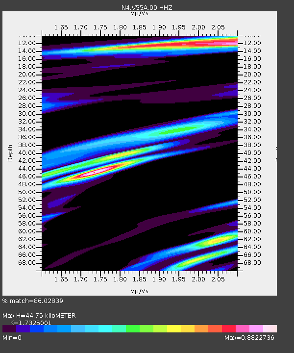
| Estimated Moho Depth: |
44.75 km |
| Estimated Crust Vp/Vs: |
1.73 |
| Assumed Crust Vp: |
6.419 km/s |
| Estimated Crust Vs: |
3.705 km/s |
| Estimated Crust Poisson's Ratio: |
0.25 |
|
| Radial Match: |
86.02839 % |
| Radial Bump: |
361 |
| Transverse Match: |
52.57307 % |
| Transverse Bump: |
400 |
| SOD ConfigId: |
23341671 |
| Insert Time: |
2020-12-28 16:34:23.061 +0000 |
| GWidth: |
2.5 |
| Max Bumps: |
400 |
| Tol: |
0.001 |
|

Signal To Noise
| Channel | StoN | STA | LTA |
| N4:V55A:00:HHZ:20201214T15:30:03.678977Z | 6.956635 | 2.183059E-6 | 3.1380964E-7 |
| N4:V55A:00:HH1:20201214T15:30:03.678977Z | 7.7246194 | 1.1316872E-6 | 1.4650395E-7 |
| N4:V55A:00:HH2:20201214T15:30:03.678977Z | 1.9167949 | 4.419255E-7 | 2.305544E-7 |
| Arrivals |
| Ps | 5.4 SECOND |
| PpPs | 18 SECOND |
| PsPs/PpSs | 24 SECOND |


