You are here: Home > Network List > NM - Cooperative New Madrid Seismic Network Stations List
> Station UTMT Martin, TN > Earthquake Result Viewer
UTMT Martin, TN - Earthquake Result Viewer
| Earthquake location: |
Chile-Bolivia Border Region |
| Earthquake latitude/longitude: |
-21.8/-68.7 |
| Earthquake time(UTC): |
2020/12/14 (349) 15:20:49 GMT |
| Earthquake Depth: |
111 km |
| Earthquake Magnitude: |
6.0 Mww |
| Earthquake Catalog/Contributor: |
NEIC PDE/us |
|
| Network: |
NM Cooperative New Madrid Seismic Network |
| Station: |
UTMT Martin, TN |
| Lat/Lon: |
36.35 N/88.86 W |
| Elevation: |
110 m |
|
| Distance: |
60.9 deg |
| Az: |
341.425 deg |
| Baz: |
158.49 deg |
| Ray Param: |
0.060902648 |
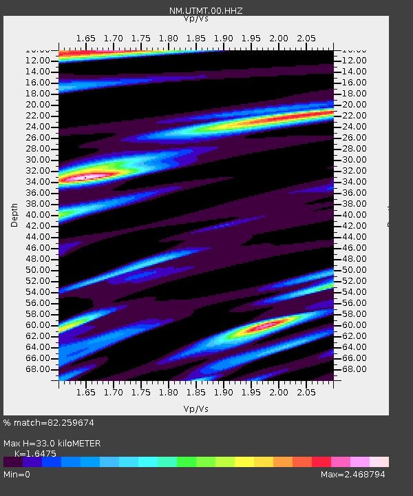
| Estimated Moho Depth: |
33.0 km |
| Estimated Crust Vp/Vs: |
1.65 |
| Assumed Crust Vp: |
6.444 km/s |
| Estimated Crust Vs: |
3.911 km/s |
| Estimated Crust Poisson's Ratio: |
0.21 |
|
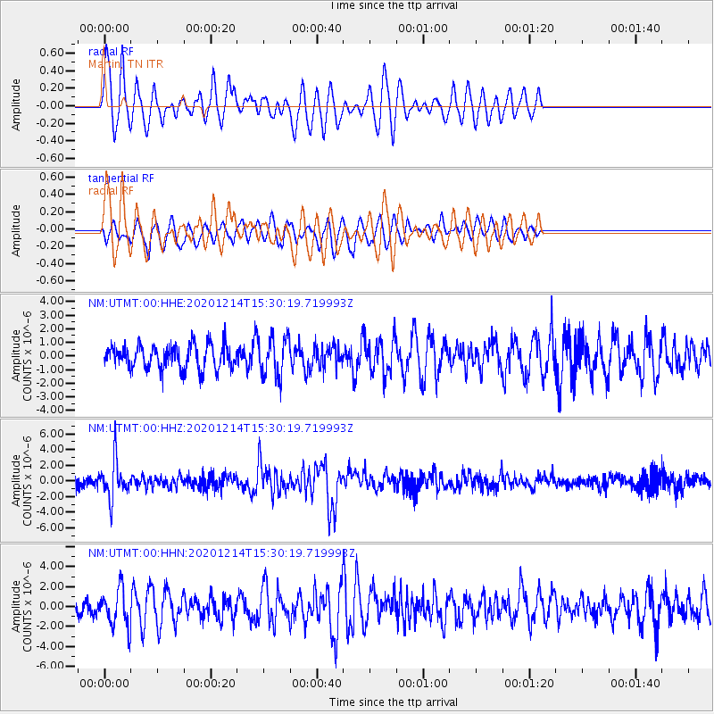
| Radial Match: |
82.259674 % |
| Radial Bump: |
400 |
| Transverse Match: |
63.32261 % |
| Transverse Bump: |
382 |
| SOD ConfigId: |
23341671 |
| Insert Time: |
2020-12-28 16:35:30.064 +0000 |
| GWidth: |
2.5 |
| Max Bumps: |
400 |
| Tol: |
0.001 |
|
Signal To Noise
| Channel | StoN | STA | LTA |
| NM:UTMT:00:HHZ:20201214T15:30:19.719993Z | 4.227026 | 2.4645974E-6 | 5.830571E-7 |
| NM:UTMT:00:HHN:20201214T15:30:19.719993Z | 2.6188805 | 1.9006617E-6 | 7.257535E-7 |
| NM:UTMT:00:HHE:20201214T15:30:19.719993Z | 1.6066278 | 1.4188606E-6 | 8.8312964E-7 |
| Arrivals |
| Ps | 3.5 SECOND |
| PpPs | 13 SECOND |
| PsPs/PpSs | 16 SECOND |


