You are here: Home > Network List > GE - GEOFON Stations List
> Station SANT GEOFON Station Santorini, Greece > Earthquake Result Viewer
SANT GEOFON Station Santorini, Greece - Earthquake Result Viewer
| Earthquake location: |
Taiwan Region |
| Earthquake latitude/longitude: |
24.5/122.7 |
| Earthquake time(UTC): |
2004/10/15 (289) 04:08:50 GMT |
| Earthquake Depth: |
94 km |
| Earthquake Magnitude: |
6.4 MB, 6.7 MW, 6.6 MW |
| Earthquake Catalog/Contributor: |
WHDF/NEIC |
|
| Network: |
GE GEOFON |
| Station: |
SANT GEOFON Station Santorini, Greece |
| Lat/Lon: |
36.37 N/25.46 E |
| Elevation: |
540 m |
|
| Distance: |
81.3 deg |
| Az: |
305.907 deg |
| Baz: |
66.071 deg |
| Ray Param: |
0.047474008 |
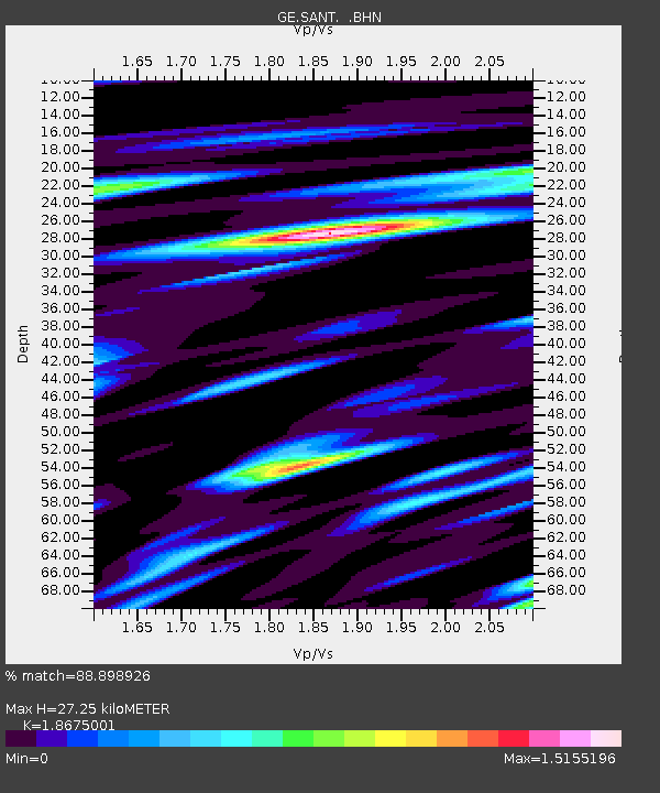
| Estimated Moho Depth: |
27.25 km |
| Estimated Crust Vp/Vs: |
1.87 |
| Assumed Crust Vp: |
5.738 km/s |
| Estimated Crust Vs: |
3.073 km/s |
| Estimated Crust Poisson's Ratio: |
0.30 |
|
| Radial Match: |
88.898926 % |
| Radial Bump: |
400 |
| Transverse Match: |
74.46143 % |
| Transverse Bump: |
400 |
| SOD ConfigId: |
2459 |
| Insert Time: |
2010-03-09 04:05:31.531 +0000 |
| GWidth: |
2.5 |
| Max Bumps: |
400 |
| Tol: |
0.001 |
|

Signal To Noise
| Channel | StoN | STA | LTA |
| GE:SANT: :BHN:20041015T04:20:25.161021Z | 2.779084 | 4.791907E-7 | 1.7242756E-7 |
| GE:SANT: :BHE:20041015T04:20:25.161021Z | 7.0496917 | 1.0766113E-6 | 1.527175E-7 |
| GE:SANT: :BHZ:20041015T04:20:25.161021Z | 34.930492 | 3.6229594E-6 | 1.03719096E-7 |
| Arrivals |
| Ps | 4.2 SECOND |
| PpPs | 13 SECOND |
| PsPs/PpSs | 18 SECOND |


