You are here: Home > Network List > GE - GEOFON Stations List
> Station SANT GEOFON Station Santorini, Greece > Earthquake Result Viewer
SANT GEOFON Station Santorini, Greece - Earthquake Result Viewer
| Earthquake location: |
Afghanistan-Tajikistan Bord Reg. |
| Earthquake latitude/longitude: |
36.5/71.0 |
| Earthquake time(UTC): |
2004/04/05 (096) 21:24:04 GMT |
| Earthquake Depth: |
187 km |
| Earthquake Magnitude: |
6.4 MB, 6.6 MW, 6.5 MW |
| Earthquake Catalog/Contributor: |
WHDF/NEIC |
|
| Network: |
GE GEOFON |
| Station: |
SANT GEOFON Station Santorini, Greece |
| Lat/Lon: |
36.37 N/25.46 E |
| Elevation: |
540 m |
|
| Distance: |
36.4 deg |
| Az: |
283.744 deg |
| Baz: |
75.841 deg |
| Ray Param: |
0.076027885 |
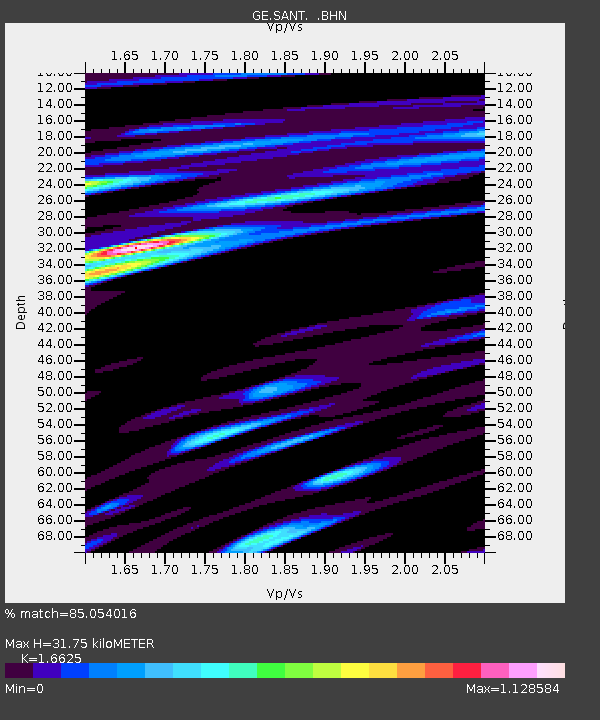
| Estimated Moho Depth: |
31.75 km |
| Estimated Crust Vp/Vs: |
1.66 |
| Assumed Crust Vp: |
5.738 km/s |
| Estimated Crust Vs: |
3.452 km/s |
| Estimated Crust Poisson's Ratio: |
0.22 |
|
| Radial Match: |
85.054016 % |
| Radial Bump: |
400 |
| Transverse Match: |
77.10198 % |
| Transverse Bump: |
397 |
| SOD ConfigId: |
2459 |
| Insert Time: |
2010-03-09 04:05:35.167 +0000 |
| GWidth: |
2.5 |
| Max Bumps: |
400 |
| Tol: |
0.001 |
|

Signal To Noise
| Channel | StoN | STA | LTA |
| GE:SANT: :BHN:20040405T21:30:19.924011Z | 11.916015 | 3.07414E-6 | 2.579839E-7 |
| GE:SANT: :BHE:20040405T21:30:19.924011Z | 25.55107 | 7.2961657E-6 | 2.8555226E-7 |
| GE:SANT: :BHZ:20040405T21:30:19.924011Z | 97.809 | 1.1412447E-5 | 1.1668095E-7 |
| Arrivals |
| Ps | 3.9 SECOND |
| PpPs | 14 SECOND |
| PsPs/PpSs | 18 SECOND |


