You are here: Home > Network List > PR - Puerto Rico Seismic Network (PRSN) & Puerto Rico Strong Motion Program (PRSMP) Stations List
> Station CELP Cerrilos Dam > Earthquake Result Viewer
CELP Cerrilos Dam - Earthquake Result Viewer
| Earthquake location: |
Chile-Bolivia Border Region |
| Earthquake latitude/longitude: |
-21.8/-68.7 |
| Earthquake time(UTC): |
2020/12/14 (349) 15:20:49 GMT |
| Earthquake Depth: |
111 km |
| Earthquake Magnitude: |
6.0 Mww |
| Earthquake Catalog/Contributor: |
NEIC PDE/us |
|
| Network: |
PR Puerto Rico Seismic Network (PRSN) & Puerto Rico Strong Motion Program (PRSMP) |
| Station: |
CELP Cerrilos Dam |
| Lat/Lon: |
18.07 N/66.58 W |
| Elevation: |
196 m |
|
| Distance: |
39.7 deg |
| Az: |
3.151 deg |
| Baz: |
183.078 deg |
| Ray Param: |
0.07446136 |
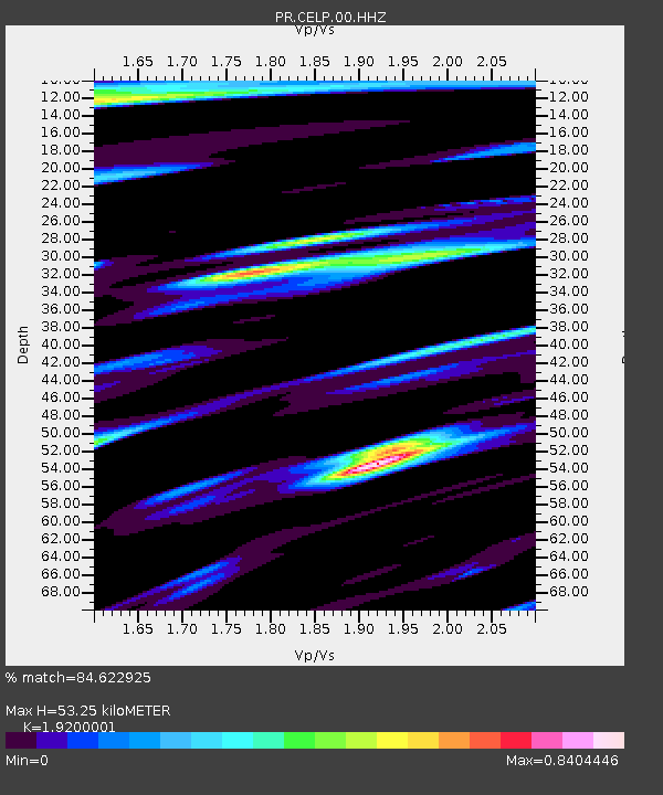
| Estimated Moho Depth: |
53.25 km |
| Estimated Crust Vp/Vs: |
1.92 |
| Assumed Crust Vp: |
5.14 km/s |
| Estimated Crust Vs: |
2.677 km/s |
| Estimated Crust Poisson's Ratio: |
0.31 |
|
| Radial Match: |
84.622925 % |
| Radial Bump: |
400 |
| Transverse Match: |
70.87519 % |
| Transverse Bump: |
400 |
| SOD ConfigId: |
23341671 |
| Insert Time: |
2020-12-28 16:40:01.448 +0000 |
| GWidth: |
2.5 |
| Max Bumps: |
400 |
| Tol: |
0.001 |
|

Signal To Noise
| Channel | StoN | STA | LTA |
| PR:CELP:00:HHZ:20201214T15:27:40.290Z | 5.663086 | 1.426073E-6 | 2.5181907E-7 |
| PR:CELP:00:HH1:20201214T15:27:40.290Z | 2.028531 | 5.720828E-7 | 2.8201825E-7 |
| PR:CELP:00:HH2:20201214T15:27:40.290Z | 2.0629303 | 5.022866E-7 | 2.4348208E-7 |
| Arrivals |
| Ps | 9.9 SECOND |
| PpPs | 29 SECOND |
| PsPs/PpSs | 39 SECOND |


