You are here: Home > Network List > US - United States National Seismic Network Stations List
> Station WMOK Wichita Mountains, Oklahoma, USA > Earthquake Result Viewer
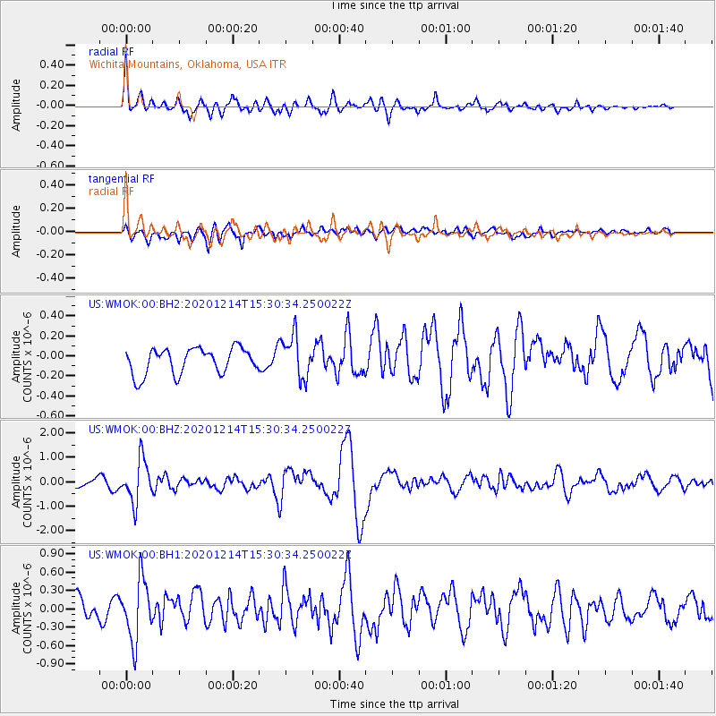
WMOK Wichita Mountains, Oklahoma, USA - Earthquake Result Viewer
*The percent match for this event was below the threshold and hence no stack was calculated.
| Earthquake location: |
Chile-Bolivia Border Region |
| Earthquake latitude/longitude: |
-21.8/-68.7 |
| Earthquake time(UTC): |
2020/12/14 (349) 15:20:49 GMT |
| Earthquake Depth: |
111 km |
| Earthquake Magnitude: |
6.0 Mww |
| Earthquake Catalog/Contributor: |
NEIC PDE/us |
|
| Network: |
US United States National Seismic Network |
| Station: |
WMOK Wichita Mountains, Oklahoma, USA |
| Lat/Lon: |
34.74 N/98.78 W |
| Elevation: |
486 m |
|
| Distance: |
63.1 deg |
| Az: |
332.419 deg |
| Baz: |
148.504 deg |
| Ray Param: |
$rayparam |
*The percent match for this event was below the threshold and hence was not used in the summary stack. |
|
| Radial Match: |
78.5082 % |
| Radial Bump: |
400 |
| Transverse Match: |
53.364887 % |
| Transverse Bump: |
400 |
| SOD ConfigId: |
23341671 |
| Insert Time: |
2020-12-28 16:45:01.051 +0000 |
| GWidth: |
2.5 |
| Max Bumps: |
400 |
| Tol: |
0.001 |
|
Signal To Noise
| Channel | StoN | STA | LTA |
| US:WMOK:00:BHZ:20201214T15:30:34.250022Z | 5.3302164 | 8.735138E-7 | 1.638796E-7 |
| US:WMOK:00:BH1:20201214T15:30:34.250022Z | 3.1899207 | 5.000659E-7 | 1.5676436E-7 |
| US:WMOK:00:BH2:20201214T15:30:34.250022Z | 1.6629163 | 2.1429787E-7 | 1.288687E-7 |
| Arrivals |
| Ps | |
| PpPs | |
| PsPs/PpSs | |


