You are here: Home > Network List > IC - New China Digital Seismograph Network Stations List
> Station WMQ Urumqi, Xinjiang Province, China > Earthquake Result Viewer
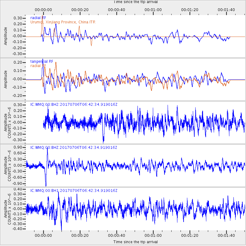
WMQ Urumqi, Xinjiang Province, China - Earthquake Result Viewer
*The percent match for this event was below the threshold and hence no stack was calculated.
| Earthquake location: |
Montana |
| Earthquake latitude/longitude: |
46.9/-112.6 |
| Earthquake time(UTC): |
2017/07/06 (187) 06:30:16 GMT |
| Earthquake Depth: |
4.3 km |
| Earthquake Magnitude: |
5.8 Mww |
| Earthquake Catalog/Contributor: |
NEIC PDE/us |
|
| Network: |
IC New China Digital Seismograph Network |
| Station: |
WMQ Urumqi, Xinjiang Province, China |
| Lat/Lon: |
43.81 N/87.70 E |
| Elevation: |
850 m |
|
| Distance: |
87.9 deg |
| Az: |
345.451 deg |
| Baz: |
13.766 deg |
| Ray Param: |
$rayparam |
*The percent match for this event was below the threshold and hence was not used in the summary stack. |
|
| Radial Match: |
59.674088 % |
| Radial Bump: |
400 |
| Transverse Match: |
65.301414 % |
| Transverse Bump: |
400 |
| SOD ConfigId: |
2364251 |
| Insert Time: |
2017-10-09 15:32:42.949 +0000 |
| GWidth: |
2.5 |
| Max Bumps: |
400 |
| Tol: |
0.001 |
|
Signal To Noise
| Channel | StoN | STA | LTA |
| IC:WMQ:00:BHZ:20170706T06:42:34.919016Z | 3.4784653 | 3.7506123E-7 | 1.07823766E-7 |
| IC:WMQ:00:BH1:20170706T06:42:34.919016Z | 1.3868297 | 9.754696E-8 | 7.0338096E-8 |
| IC:WMQ:00:BH2:20170706T06:42:34.919016Z | 1.84003 | 1.222376E-7 | 6.643239E-8 |
| Arrivals |
| Ps | |
| PpPs | |
| PsPs/PpSs | |


