You are here: Home > Network List > UW - Pacific Northwest Regional Seismic Network Stations List
> Station IRON Crane, OR, USA > Earthquake Result Viewer
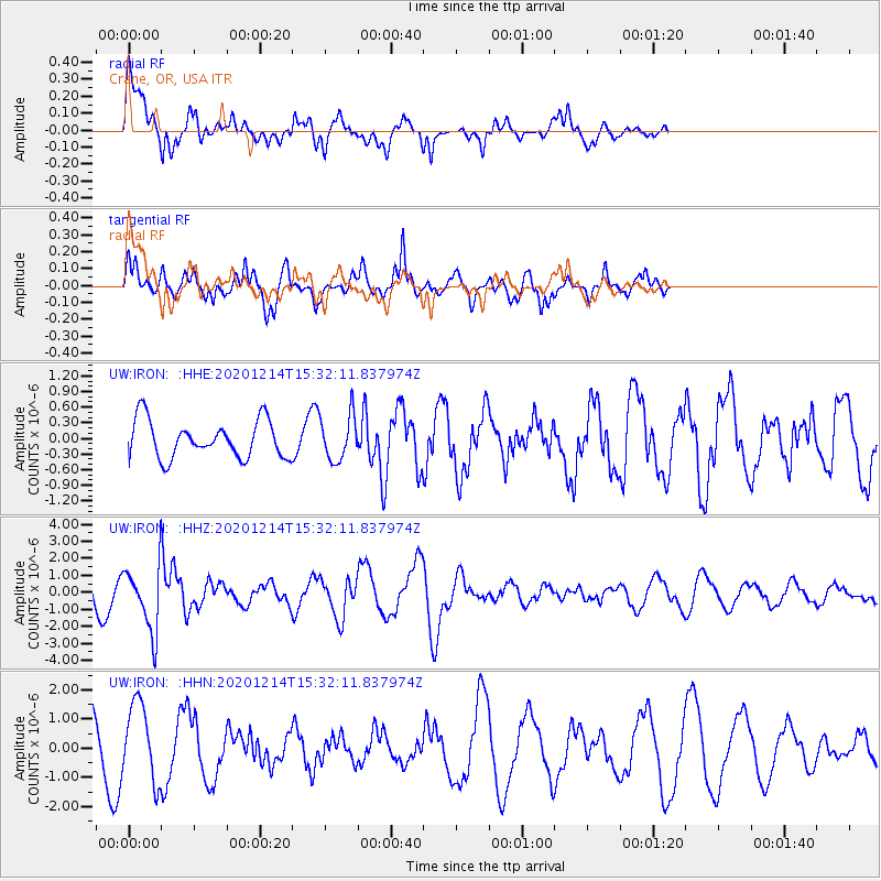
IRON Crane, OR, USA - Earthquake Result Viewer
*The percent match for this event was below the threshold and hence no stack was calculated.
| Earthquake location: |
Chile-Bolivia Border Region |
| Earthquake latitude/longitude: |
-21.8/-68.7 |
| Earthquake time(UTC): |
2020/12/14 (349) 15:20:49 GMT |
| Earthquake Depth: |
111 km |
| Earthquake Magnitude: |
6.0 Mww |
| Earthquake Catalog/Contributor: |
NEIC PDE/us |
|
| Network: |
UW Pacific Northwest Regional Seismic Network |
| Station: |
IRON Crane, OR, USA |
| Lat/Lon: |
43.36 N/118.47 W |
| Elevation: |
1226 m |
|
| Distance: |
79.3 deg |
| Az: |
325.479 deg |
| Baz: |
133.778 deg |
| Ray Param: |
$rayparam |
*The percent match for this event was below the threshold and hence was not used in the summary stack. |
|
| Radial Match: |
72.4926 % |
| Radial Bump: |
397 |
| Transverse Match: |
67.61719 % |
| Transverse Bump: |
348 |
| SOD ConfigId: |
23341671 |
| Insert Time: |
2020-12-28 16:46:12.231 +0000 |
| GWidth: |
2.5 |
| Max Bumps: |
400 |
| Tol: |
0.001 |
|
Signal To Noise
| Channel | StoN | STA | LTA |
| UW:IRON: :HHZ:20201214T15:32:11.837974Z | 2.4853356 | 1.8470322E-6 | 7.4317217E-7 |
| UW:IRON: :HHN:20201214T15:32:11.837974Z | 1.2415751 | 1.3146922E-6 | 1.0588906E-6 |
| UW:IRON: :HHE:20201214T15:32:11.837974Z | 1.2274063 | 4.3953668E-7 | 3.5810203E-7 |
| Arrivals |
| Ps | |
| PpPs | |
| PsPs/PpSs | |


