You are here: Home > Network List > YX16 - Raton Basin UNM Broadband Network Stations List
> Station UNM5 Southernmost CO Station > Earthquake Result Viewer
UNM5 Southernmost CO Station - Earthquake Result Viewer
| Earthquake location: |
Chile-Bolivia Border Region |
| Earthquake latitude/longitude: |
-21.8/-68.7 |
| Earthquake time(UTC): |
2020/12/14 (349) 15:20:49 GMT |
| Earthquake Depth: |
111 km |
| Earthquake Magnitude: |
6.0 Mww |
| Earthquake Catalog/Contributor: |
NEIC PDE/us |
|
| Network: |
YX Raton Basin UNM Broadband Network |
| Station: |
UNM5 Southernmost CO Station |
| Lat/Lon: |
37.12 N/104.78 W |
| Elevation: |
2035 m |
|
| Distance: |
67.8 deg |
| Az: |
329.429 deg |
| Baz: |
143.75 deg |
| Ray Param: |
0.056452066 |
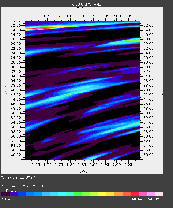
| Estimated Moho Depth: |
13.75 km |
| Estimated Crust Vp/Vs: |
1.60 |
| Assumed Crust Vp: |
6.316 km/s |
| Estimated Crust Vs: |
3.947 km/s |
| Estimated Crust Poisson's Ratio: |
0.18 |
|
| Radial Match: |
81.8997 % |
| Radial Bump: |
400 |
| Transverse Match: |
46.920612 % |
| Transverse Bump: |
322 |
| SOD ConfigId: |
23341671 |
| Insert Time: |
2020-12-28 16:48:07.129 +0000 |
| GWidth: |
2.5 |
| Max Bumps: |
400 |
| Tol: |
0.001 |
|

Signal To Noise
| Channel | StoN | STA | LTA |
| YX:UNM5: :HHZ:20201214T15:31:04.360007Z | 6.486731 | 1.7916323E-6 | 2.761996E-7 |
| YX:UNM5: :HHN:20201214T15:31:04.360007Z | 3.2116277 | 5.9461973E-7 | 1.8514591E-7 |
| YX:UNM5: :HHE:20201214T15:31:04.360007Z | 2.4363475 | 6.733677E-7 | 2.763841E-7 |
| Arrivals |
| Ps | 1.4 SECOND |
| PpPs | 5.4 SECOND |
| PsPs/PpSs | 6.8 SECOND |


