You are here: Home > Network List > CI - Caltech Regional Seismic Network Stations List
> Station MPM Manuel Prospect Mine, California, USA > Earthquake Result Viewer
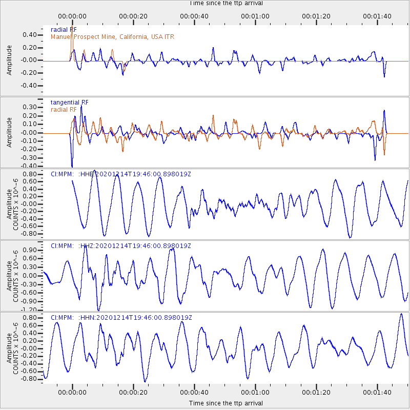
MPM Manuel Prospect Mine, California, USA - Earthquake Result Viewer
*The percent match for this event was below the threshold and hence no stack was calculated.
| Earthquake location: |
Norwegian Sea |
| Earthquake latitude/longitude: |
72.2/0.8 |
| Earthquake time(UTC): |
2020/12/14 (349) 19:35:59 GMT |
| Earthquake Depth: |
10 km |
| Earthquake Magnitude: |
5.8 Mww |
| Earthquake Catalog/Contributor: |
NEIC PDE/us |
|
| Network: |
CI Caltech Regional Seismic Network |
| Station: |
MPM Manuel Prospect Mine, California, USA |
| Lat/Lon: |
36.06 N/117.49 W |
| Elevation: |
185 m |
|
| Distance: |
63.9 deg |
| Az: |
307.37 deg |
| Baz: |
17.531 deg |
| Ray Param: |
$rayparam |
*The percent match for this event was below the threshold and hence was not used in the summary stack. |
|
| Radial Match: |
64.33804 % |
| Radial Bump: |
400 |
| Transverse Match: |
63.405415 % |
| Transverse Bump: |
342 |
| SOD ConfigId: |
23341671 |
| Insert Time: |
2020-12-28 20:42:22.892 +0000 |
| GWidth: |
2.5 |
| Max Bumps: |
400 |
| Tol: |
0.001 |
|
Signal To Noise
| Channel | StoN | STA | LTA |
| CI:MPM: :HHZ:20201214T19:46:00.898019Z | 2.6517653 | 5.773457E-7 | 2.1772125E-7 |
| CI:MPM: :HHN:20201214T19:46:00.898019Z | 1.3274707 | 4.3081667E-7 | 3.245395E-7 |
| CI:MPM: :HHE:20201214T19:46:00.898019Z | 0.76708144 | 4.0521928E-7 | 5.282611E-7 |
| Arrivals |
| Ps | |
| PpPs | |
| PsPs/PpSs | |


