You are here: Home > Network List > SP - South Carolina Earth Physics Project Stations List
> Station SUMMR Summerville High School, Dorchester County, SC USA > Earthquake Result Viewer
SUMMR Summerville High School, Dorchester County, SC USA - Earthquake Result Viewer

| Earthquake location: |
Central Alaska |
| Earthquake latitude/longitude: |
63.5/-147.4 |
| Earthquake time(UTC): |
2002/11/03 (307) 22:12:41 GMT |
| Earthquake Depth: |
4.9 km |
| Earthquake Magnitude: |
7.0 MB, 8.5 MS, 7.9 MW |
| Earthquake Catalog/Contributor: |
WHDF/NEIC |
|
| Network: |
SP South Carolina Earth Physics Project |
| Station: |
SUMMR Summerville High School, Dorchester County, SC USA |
| Lat/Lon: |
32.99 N/80.22 W |
| Elevation: |
35 m |
|
| Distance: |
50.9 deg |
| Az: |
93.53 deg |
| Baz: |
327.827 deg |
| Ray Param: |
0.06774581 |
| Estimated Moho Depth: |
14.5 km |
| Estimated Crust Vp/Vs: |
1.60 |
| Assumed Crust Vp: |
6.565 km/s |
| Estimated Crust Vs: |
4.103 km/s |
| Estimated Crust Poisson's Ratio: |
0.18 |
|
| Radial Match: |
97.65126 % |
| Radial Bump: |
322 |
| Transverse Match: |
81.690956 % |
| Transverse Bump: |
400 |
| SOD ConfigId: |
2277 |
| Insert Time: |
2010-02-25 17:50:51.332 +0000 |
| GWidth: |
2.5 |
| Max Bumps: |
400 |
| Tol: |
0.001 |
|
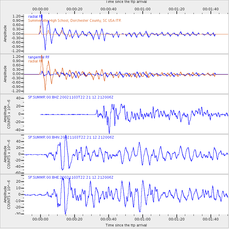
Signal To Noise
| Channel | StoN | STA | LTA |
| SP:SUMMR:00:BHN:20021103T22:21:12.212006Z | 5.118623 | 2.5642487E-6 | 5.009646E-7 |
| SP:SUMMR:00:BHE:20021103T22:21:12.212006Z | 3.1476538 | 1.5293901E-6 | 4.858826E-7 |
| SP:SUMMR:00:BHZ:20021103T22:21:12.212006Z | 32.73551 | 3.5570854E-6 | 1.08661375E-7 |
| Arrivals |
| Ps | 1.4 SECOND |
| PpPs | 5.4 SECOND |
| PsPs/PpSs | 6.8 SECOND |


