You are here: Home > Network List > TA - USArray Transportable Network (new EarthScope stations) Stations List
> Station F26K Sheenjek River, AK, USA > Earthquake Result Viewer
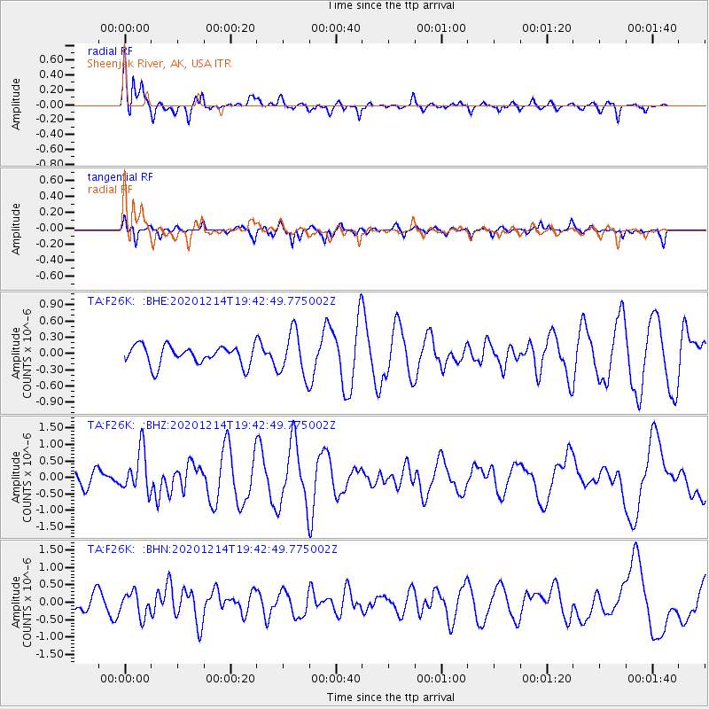
F26K Sheenjek River, AK, USA - Earthquake Result Viewer
*The percent match for this event was below the threshold and hence no stack was calculated.
| Earthquake location: |
Norwegian Sea |
| Earthquake latitude/longitude: |
72.2/0.8 |
| Earthquake time(UTC): |
2020/12/14 (349) 19:35:59 GMT |
| Earthquake Depth: |
10 km |
| Earthquake Magnitude: |
5.8 Mww |
| Earthquake Catalog/Contributor: |
NEIC PDE/us |
|
| Network: |
TA USArray Transportable Network (new EarthScope stations) |
| Station: |
F26K Sheenjek River, AK, USA |
| Lat/Lon: |
67.69 N/144.15 W |
| Elevation: |
683 m |
|
| Distance: |
38.4 deg |
| Az: |
339.316 deg |
| Baz: |
16.51 deg |
| Ray Param: |
$rayparam |
*The percent match for this event was below the threshold and hence was not used in the summary stack. |
|
| Radial Match: |
74.42135 % |
| Radial Bump: |
400 |
| Transverse Match: |
68.01212 % |
| Transverse Bump: |
329 |
| SOD ConfigId: |
23341671 |
| Insert Time: |
2020-12-28 20:55:29.390 +0000 |
| GWidth: |
2.5 |
| Max Bumps: |
400 |
| Tol: |
0.001 |
|
Signal To Noise
| Channel | StoN | STA | LTA |
| TA:F26K: :BHZ:20201214T19:42:49.775002Z | 2.7006445 | 6.37549E-7 | 2.3607292E-7 |
| TA:F26K: :BHN:20201214T19:42:49.775002Z | 1.2113893 | 3.4210782E-7 | 2.8240947E-7 |
| TA:F26K: :BHE:20201214T19:42:49.775002Z | 2.3481407 | 4.1200894E-7 | 1.7546178E-7 |
| Arrivals |
| Ps | |
| PpPs | |
| PsPs/PpSs | |


