You are here: Home > Network List > US - United States National Seismic Network Stations List
> Station DGMT Dagmar, Montana, USA > Earthquake Result Viewer
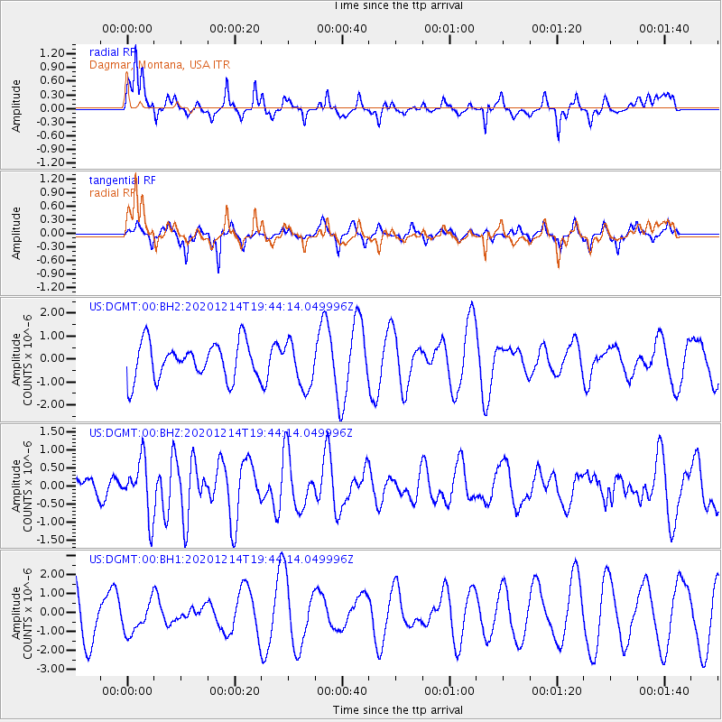
DGMT Dagmar, Montana, USA - Earthquake Result Viewer
*The percent match for this event was below the threshold and hence no stack was calculated.
| Earthquake location: |
Norwegian Sea |
| Earthquake latitude/longitude: |
72.2/0.8 |
| Earthquake time(UTC): |
2020/12/14 (349) 19:35:59 GMT |
| Earthquake Depth: |
10 km |
| Earthquake Magnitude: |
5.8 Mww |
| Earthquake Catalog/Contributor: |
NEIC PDE/us |
|
| Network: |
US United States National Seismic Network |
| Station: |
DGMT Dagmar, Montana, USA |
| Lat/Lon: |
48.47 N/104.20 W |
| Elevation: |
0.0 m |
|
| Distance: |
48.9 deg |
| Az: |
301.422 deg |
| Baz: |
23.192 deg |
| Ray Param: |
$rayparam |
*The percent match for this event was below the threshold and hence was not used in the summary stack. |
|
| Radial Match: |
73.10424 % |
| Radial Bump: |
400 |
| Transverse Match: |
48.714355 % |
| Transverse Bump: |
273 |
| SOD ConfigId: |
23341671 |
| Insert Time: |
2020-12-28 20:58:05.325 +0000 |
| GWidth: |
2.5 |
| Max Bumps: |
400 |
| Tol: |
0.001 |
|
Signal To Noise
| Channel | StoN | STA | LTA |
| US:DGMT:00:BHZ:20201214T19:44:14.049996Z | 3.8828938 | 7.646536E-7 | 1.9692878E-7 |
| US:DGMT:00:BH1:20201214T19:44:14.049996Z | 0.6383535 | 8.175858E-7 | 1.2807727E-6 |
| US:DGMT:00:BH2:20201214T19:44:14.049996Z | 1.2468232 | 9.82895E-7 | 7.883195E-7 |
| Arrivals |
| Ps | |
| PpPs | |
| PsPs/PpSs | |


