You are here: Home > Network List > GO - National Seismic Network of Georgia Stations List
> Station TBLG Delisi, Georgia > Earthquake Result Viewer
TBLG Delisi, Georgia - Earthquake Result Viewer
| Earthquake location: |
Mindanao, Philippines |
| Earthquake latitude/longitude: |
5.2/125.4 |
| Earthquake time(UTC): |
2020/12/15 (350) 23:21:59 GMT |
| Earthquake Depth: |
27 km |
| Earthquake Magnitude: |
6.1 mww |
| Earthquake Catalog/Contributor: |
NEIC PDE/us |
|
| Network: |
GO National Seismic Network of Georgia |
| Station: |
TBLG Delisi, Georgia |
| Lat/Lon: |
41.73 N/44.74 E |
| Elevation: |
510 m |
|
| Distance: |
79.6 deg |
| Az: |
311.327 deg |
| Baz: |
92.286 deg |
| Ray Param: |
0.048808254 |
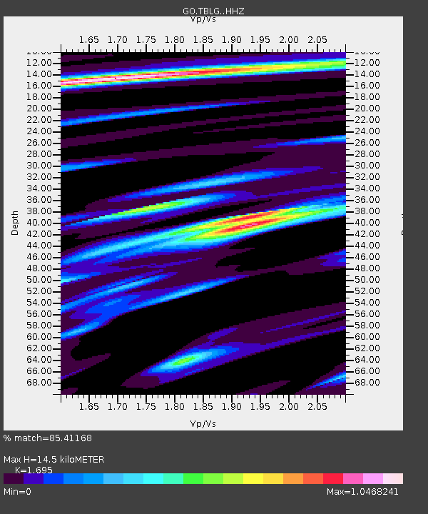
| Estimated Moho Depth: |
14.5 km |
| Estimated Crust Vp/Vs: |
1.70 |
| Assumed Crust Vp: |
6.291 km/s |
| Estimated Crust Vs: |
3.711 km/s |
| Estimated Crust Poisson's Ratio: |
0.23 |
|
| Radial Match: |
85.41168 % |
| Radial Bump: |
386 |
| Transverse Match: |
74.26943 % |
| Transverse Bump: |
400 |
| SOD ConfigId: |
23341671 |
| Insert Time: |
2020-12-30 00:29:46.522 +0000 |
| GWidth: |
2.5 |
| Max Bumps: |
400 |
| Tol: |
0.001 |
|

Signal To Noise
| Channel | StoN | STA | LTA |
| GO:TBLG: :HHZ:20201215T23:33:32.969973Z | 4.6719418 | 6.380422E-7 | 1.3656896E-7 |
| GO:TBLG: :HHN:20201215T23:33:32.969973Z | 0.8456455 | 1.4816918E-7 | 1.752143E-7 |
| GO:TBLG: :HHE:20201215T23:33:32.969973Z | 1.8760571 | 1.7994772E-7 | 9.591803E-8 |
| Arrivals |
| Ps | 1.6 SECOND |
| PpPs | 6.0 SECOND |
| PsPs/PpSs | 7.7 SECOND |


