You are here: Home > Network List > MM - Myanmar National Seismic Network Stations List
> Station TMU Tamu, Sagaing, Myanmar > Earthquake Result Viewer
TMU Tamu, Sagaing, Myanmar - Earthquake Result Viewer
| Earthquake location: |
Mindanao, Philippines |
| Earthquake latitude/longitude: |
5.2/125.4 |
| Earthquake time(UTC): |
2020/12/15 (350) 23:21:59 GMT |
| Earthquake Depth: |
27 km |
| Earthquake Magnitude: |
6.1 mww |
| Earthquake Catalog/Contributor: |
NEIC PDE/us |
|
| Network: |
MM Myanmar National Seismic Network |
| Station: |
TMU Tamu, Sagaing, Myanmar |
| Lat/Lon: |
24.23 N/94.30 E |
| Elevation: |
182 m |
|
| Distance: |
35.4 deg |
| Az: |
305.44 deg |
| Baz: |
117.279 deg |
| Ray Param: |
0.077195495 |
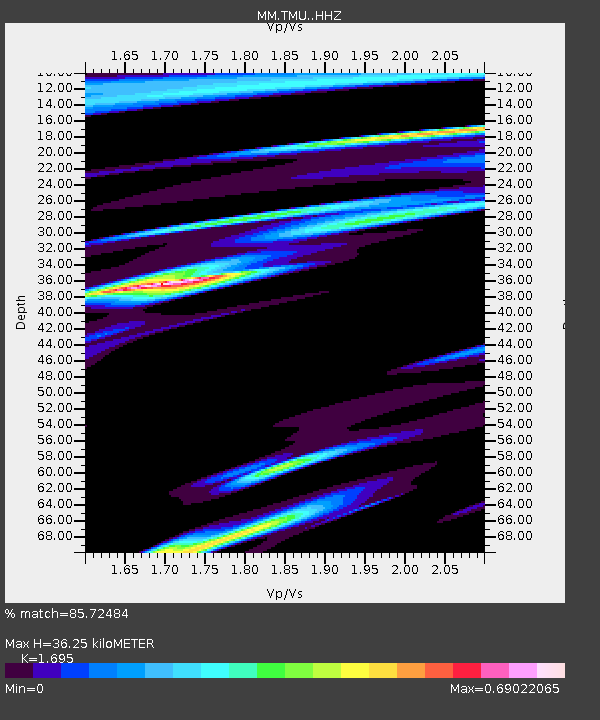
| Estimated Moho Depth: |
36.25 km |
| Estimated Crust Vp/Vs: |
1.70 |
| Assumed Crust Vp: |
6.316 km/s |
| Estimated Crust Vs: |
3.726 km/s |
| Estimated Crust Poisson's Ratio: |
0.23 |
|
| Radial Match: |
85.72484 % |
| Radial Bump: |
353 |
| Transverse Match: |
66.1708 % |
| Transverse Bump: |
400 |
| SOD ConfigId: |
23341671 |
| Insert Time: |
2020-12-30 00:31:38.873 +0000 |
| GWidth: |
2.5 |
| Max Bumps: |
400 |
| Tol: |
0.001 |
|

Signal To Noise
| Channel | StoN | STA | LTA |
| MM:TMU: :HHZ:20201215T23:28:22.488009Z | 4.6941705 | 3.6666034E-7 | 7.810972E-8 |
| MM:TMU: :HHN:20201215T23:28:22.488009Z | 0.53999376 | 4.1939705E-7 | 7.766702E-7 |
| MM:TMU: :HHE:20201215T23:28:22.488009Z | 1.6663054 | 1.7886065E-7 | 1.0733966E-7 |
| Arrivals |
| Ps | 4.3 SECOND |
| PpPs | 14 SECOND |
| PsPs/PpSs | 19 SECOND |


