You are here: Home > Network List > TA - USArray Transportable Network (new EarthScope stations) Stations List
> Station G21K Allakaket, AK, USA > Earthquake Result Viewer
G21K Allakaket, AK, USA - Earthquake Result Viewer
| Earthquake location: |
Mindanao, Philippines |
| Earthquake latitude/longitude: |
5.2/125.4 |
| Earthquake time(UTC): |
2020/12/15 (350) 23:21:59 GMT |
| Earthquake Depth: |
27 km |
| Earthquake Magnitude: |
6.1 mww |
| Earthquake Catalog/Contributor: |
NEIC PDE/us |
|
| Network: |
TA USArray Transportable Network (new EarthScope stations) |
| Station: |
G21K Allakaket, AK, USA |
| Lat/Lon: |
66.52 N/153.51 W |
| Elevation: |
446 m |
|
| Distance: |
81.7 deg |
| Az: |
23.584 deg |
| Baz: |
263.865 deg |
| Ray Param: |
0.047387667 |
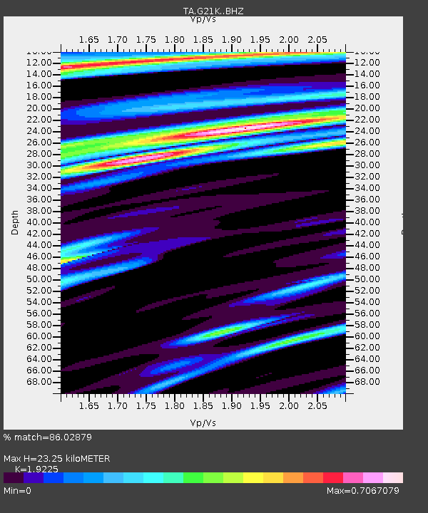
| Estimated Moho Depth: |
23.25 km |
| Estimated Crust Vp/Vs: |
1.92 |
| Assumed Crust Vp: |
6.455 km/s |
| Estimated Crust Vs: |
3.358 km/s |
| Estimated Crust Poisson's Ratio: |
0.31 |
|
| Radial Match: |
86.02879 % |
| Radial Bump: |
400 |
| Transverse Match: |
78.03707 % |
| Transverse Bump: |
400 |
| SOD ConfigId: |
23341671 |
| Insert Time: |
2020-12-30 00:33:13.062 +0000 |
| GWidth: |
2.5 |
| Max Bumps: |
400 |
| Tol: |
0.001 |
|
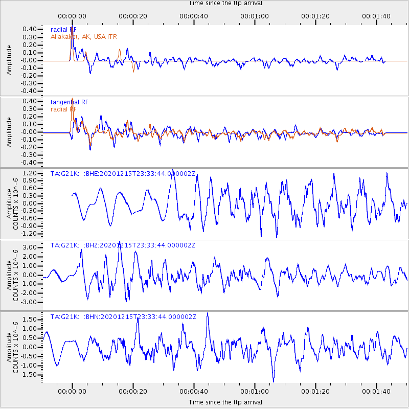
Signal To Noise
| Channel | StoN | STA | LTA |
| TA:G21K: :BHZ:20201215T23:33:44.000002Z | 4.163725 | 1.2106786E-6 | 2.9076816E-7 |
| TA:G21K: :BHN:20201215T23:33:44.000002Z | 0.90206426 | 3.9360498E-7 | 4.3633804E-7 |
| TA:G21K: :BHE:20201215T23:33:44.000002Z | 1.9137691 | 7.2203625E-7 | 3.7728492E-7 |
| Arrivals |
| Ps | 3.4 SECOND |
| PpPs | 10 SECOND |
| PsPs/PpSs | 14 SECOND |


