You are here: Home > Network List > TA - USArray Transportable Network (new EarthScope stations) Stations List
> Station R33M Jennings River, BC, CAN > Earthquake Result Viewer
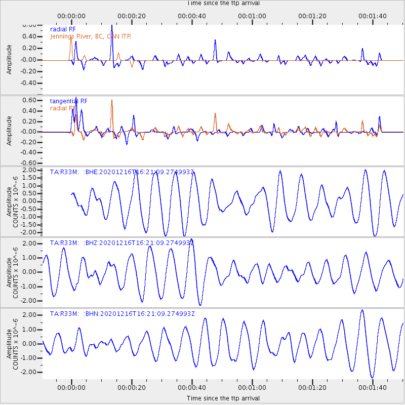
R33M Jennings River, BC, CAN - Earthquake Result Viewer
*The percent match for this event was below the threshold and hence no stack was calculated.
| Earthquake location: |
New Guinea, Papua New Guinea |
| Earthquake latitude/longitude: |
-6.4/143.2 |
| Earthquake time(UTC): |
2020/12/16 (351) 16:08:26 GMT |
| Earthquake Depth: |
14 km |
| Earthquake Magnitude: |
5.2 Mww |
| Earthquake Catalog/Contributor: |
NEIC PDE/us |
|
| Network: |
TA USArray Transportable Network (new EarthScope stations) |
| Station: |
R33M Jennings River, BC, CAN |
| Lat/Lon: |
59.39 N/130.97 W |
| Elevation: |
1437 m |
|
| Distance: |
93.3 deg |
| Az: |
30.744 deg |
| Baz: |
263.217 deg |
| Ray Param: |
$rayparam |
*The percent match for this event was below the threshold and hence was not used in the summary stack. |
|
| Radial Match: |
72.84373 % |
| Radial Bump: |
314 |
| Transverse Match: |
77.096054 % |
| Transverse Bump: |
400 |
| SOD ConfigId: |
23341671 |
| Insert Time: |
2020-12-30 17:16:34.540 +0000 |
| GWidth: |
2.5 |
| Max Bumps: |
400 |
| Tol: |
0.001 |
|
Signal To Noise
| Channel | StoN | STA | LTA |
| TA:R33M: :BHZ:20201216T16:21:09.274993Z | 0.8241807 | 8.110475E-7 | 9.840652E-7 |
| TA:R33M: :BHN:20201216T16:21:09.274993Z | 0.8329235 | 6.1394854E-7 | 7.371008E-7 |
| TA:R33M: :BHE:20201216T16:21:09.274993Z | 1.5981631 | 1.4483085E-6 | 9.062332E-7 |
| Arrivals |
| Ps | |
| PpPs | |
| PsPs/PpSs | |


