You are here: Home > Network List > CI - Caltech Regional Seismic Network Stations List
> Station SWS Sam W. Stewart, Westmorland, CA, USA > Earthquake Result Viewer
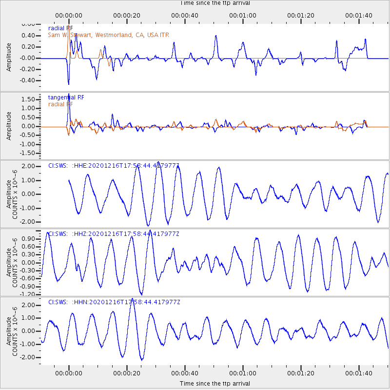
SWS Sam W. Stewart, Westmorland, CA, USA - Earthquake Result Viewer
*The percent match for this event was below the threshold and hence no stack was calculated.
| Earthquake location: |
Southern Peru |
| Earthquake latitude/longitude: |
-16.6/-71.4 |
| Earthquake time(UTC): |
2020/12/16 (351) 17:48:44 GMT |
| Earthquake Depth: |
87 km |
| Earthquake Magnitude: |
5.6 mww |
| Earthquake Catalog/Contributor: |
NEIC PDE/us |
|
| Network: |
CI Caltech Regional Seismic Network |
| Station: |
SWS Sam W. Stewart, Westmorland, CA, USA |
| Lat/Lon: |
32.94 N/115.80 W |
| Elevation: |
140 m |
|
| Distance: |
65.0 deg |
| Az: |
319.535 deg |
| Baz: |
132.255 deg |
| Ray Param: |
$rayparam |
*The percent match for this event was below the threshold and hence was not used in the summary stack. |
|
| Radial Match: |
55.552494 % |
| Radial Bump: |
400 |
| Transverse Match: |
66.02754 % |
| Transverse Bump: |
386 |
| SOD ConfigId: |
23341671 |
| Insert Time: |
2020-12-30 18:53:22.014 +0000 |
| GWidth: |
2.5 |
| Max Bumps: |
400 |
| Tol: |
0.001 |
|
Signal To Noise
| Channel | StoN | STA | LTA |
| CI:SWS: :HHZ:20201216T17:58:44.417977Z | 0.63006634 | 4.3348427E-7 | 6.8799784E-7 |
| CI:SWS: :HHN:20201216T17:58:44.417977Z | 2.5480633 | 9.211982E-7 | 3.6152875E-7 |
| CI:SWS: :HHE:20201216T17:58:44.417977Z | 1.6871147 | 1.612122E-6 | 9.555498E-7 |
| Arrivals |
| Ps | |
| PpPs | |
| PsPs/PpSs | |


