You are here: Home > Network List > NN - Western Great Basin/Eastern Sierra Nevada Stations List
> Station LCH Last Chance Range, CA. (GPS 01/04/2001) w84 > Earthquake Result Viewer
LCH Last Chance Range, CA. (GPS 01/04/2001) w84 - Earthquake Result Viewer
| Earthquake location: |
Southern Peru |
| Earthquake latitude/longitude: |
-16.6/-71.4 |
| Earthquake time(UTC): |
2020/12/16 (351) 17:48:44 GMT |
| Earthquake Depth: |
87 km |
| Earthquake Magnitude: |
5.6 mww |
| Earthquake Catalog/Contributor: |
NEIC PDE/us |
|
| Network: |
NN Western Great Basin/Eastern Sierra Nevada |
| Station: |
LCH Last Chance Range, CA. (GPS 01/04/2001) w84 |
| Lat/Lon: |
37.23 N/117.65 W |
| Elevation: |
1414 m |
|
| Distance: |
69.0 deg |
| Az: |
321.875 deg |
| Baz: |
132.112 deg |
| Ray Param: |
0.055749748 |
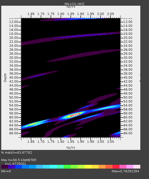
| Estimated Moho Depth: |
58.5 km |
| Estimated Crust Vp/Vs: |
1.87 |
| Assumed Crust Vp: |
6.279 km/s |
| Estimated Crust Vs: |
3.353 km/s |
| Estimated Crust Poisson's Ratio: |
0.30 |
|
| Radial Match: |
83.87782 % |
| Radial Bump: |
400 |
| Transverse Match: |
59.285027 % |
| Transverse Bump: |
400 |
| SOD ConfigId: |
23341671 |
| Insert Time: |
2020-12-30 18:59:41.574 +0000 |
| GWidth: |
2.5 |
| Max Bumps: |
400 |
| Tol: |
0.001 |
|

Signal To Noise
| Channel | StoN | STA | LTA |
| NN:LCH: :HHZ:20201216T17:59:09.667977Z | 1.3303856 | 4.84883E-7 | 3.64468E-7 |
| NN:LCH: :HHN:20201216T17:59:09.667977Z | 2.0987942 | 8.6446465E-7 | 4.1188633E-7 |
| NN:LCH: :HHE:20201216T17:59:09.667977Z | 0.3371138 | 3.297107E-7 | 9.780397E-7 |
| Arrivals |
| Ps | 8.4 SECOND |
| PpPs | 26 SECOND |
| PsPs/PpSs | 34 SECOND |


