You are here: Home > Network List > WY - Yellowstone Wyoming Seismic Network Stations List
> Station YHH Holmes Hill, YNP, WY, USA > Earthquake Result Viewer
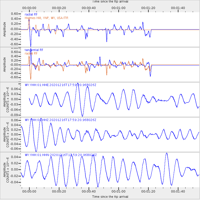
YHH Holmes Hill, YNP, WY, USA - Earthquake Result Viewer
*The percent match for this event was below the threshold and hence no stack was calculated.
| Earthquake location: |
Southern Peru |
| Earthquake latitude/longitude: |
-16.6/-71.4 |
| Earthquake time(UTC): |
2020/12/16 (351) 17:48:44 GMT |
| Earthquake Depth: |
87 km |
| Earthquake Magnitude: |
5.6 mww |
| Earthquake Catalog/Contributor: |
NEIC PDE/us |
|
| Network: |
WY Yellowstone Wyoming Seismic Network |
| Station: |
YHH Holmes Hill, YNP, WY, USA |
| Lat/Lon: |
44.79 N/110.85 W |
| Elevation: |
2717 m |
|
| Distance: |
70.8 deg |
| Az: |
331.394 deg |
| Baz: |
139.847 deg |
| Ray Param: |
$rayparam |
*The percent match for this event was below the threshold and hence was not used in the summary stack. |
|
| Radial Match: |
67.111084 % |
| Radial Bump: |
378 |
| Transverse Match: |
88.79964 % |
| Transverse Bump: |
324 |
| SOD ConfigId: |
23341671 |
| Insert Time: |
2020-12-30 19:06:21.589 +0000 |
| GWidth: |
2.5 |
| Max Bumps: |
400 |
| Tol: |
0.001 |
|
Signal To Noise
| Channel | StoN | STA | LTA |
| WY:YHH:01:HHZ:20201216T17:59:20.968026Z | 1.1772962 | 4.7487386E-8 | 4.0335973E-8 |
| WY:YHH:01:HHN:20201216T17:59:20.968026Z | 0.9433962 | 1.6542485E-8 | 1.7535035E-8 |
| WY:YHH:01:HHE:20201216T17:59:20.968026Z | 2.5112245 | 6.138269E-8 | 2.4443331E-8 |
| Arrivals |
| Ps | |
| PpPs | |
| PsPs/PpSs | |


