You are here: Home > Network List > GS - US Geological Survey Networks Stations List
> Station DEC06 Boomer > Earthquake Result Viewer
DEC06 Boomer - Earthquake Result Viewer
*The percent match for this event was below the threshold and hence no stack was calculated.
| Earthquake location: |
North Atlantic Ocean |
| Earthquake latitude/longitude: |
13.4/-49.4 |
| Earthquake time(UTC): |
2017/07/27 (208) 17:53:25 GMT |
| Earthquake Depth: |
10 km |
| Earthquake Magnitude: |
5.9 Mww |
| Earthquake Catalog/Contributor: |
NEIC PDE/us |
|
| Network: |
GS US Geological Survey Networks |
| Station: |
DEC06 Boomer |
| Lat/Lon: |
39.90 N/88.95 W |
| Elevation: |
215 m |
|
| Distance: |
43.6 deg |
| Az: |
314.72 deg |
| Baz: |
115.991 deg |
| Ray Param: |
$rayparam |
*The percent match for this event was below the threshold and hence was not used in the summary stack. |
|
| Radial Match: |
41.018353 % |
| Radial Bump: |
400 |
| Transverse Match: |
36.473564 % |
| Transverse Bump: |
400 |
| SOD ConfigId: |
2364251 |
| Insert Time: |
2017-10-09 17:10:05.552 +0000 |
| GWidth: |
2.5 |
| Max Bumps: |
400 |
| Tol: |
0.001 |
|
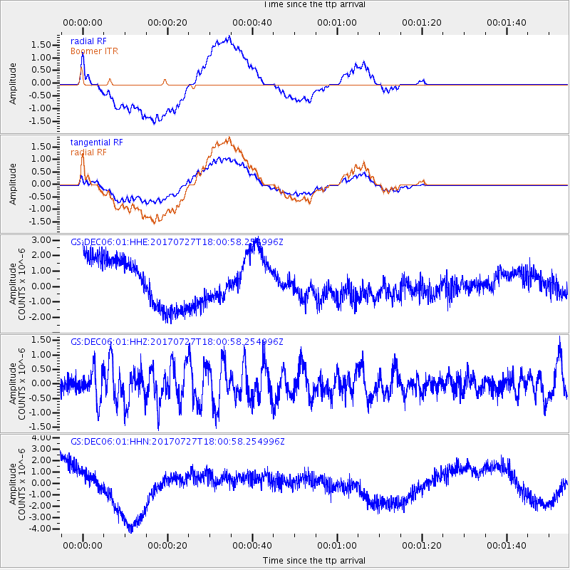
Signal To Noise
| Channel | StoN | STA | LTA |
| GS:DEC06:01:HHZ:20170727T18:00:58.254996Z | 2.4515953 | 5.3253467E-7 | 2.1721965E-7 |
| GS:DEC06:01:HHN:20170727T18:00:58.254996Z | 0.35259533 | 8.300583E-7 | 2.3541386E-6 |
| GS:DEC06:01:HHE:20170727T18:00:58.254996Z | 0.58277637 | 9.029542E-7 | 1.5494008E-6 |
| Arrivals |
| Ps | |
| PpPs | |
| PsPs/PpSs | |


