You are here: Home > Network List > IW - Intermountain West Stations List
> Station MFID Near Bowns Crk and Slater Flat Rd, Idaho, USA > Earthquake Result Viewer
MFID Near Bowns Crk and Slater Flat Rd, Idaho, USA - Earthquake Result Viewer
| Earthquake location: |
North Atlantic Ocean |
| Earthquake latitude/longitude: |
13.4/-49.4 |
| Earthquake time(UTC): |
2017/07/27 (208) 17:53:25 GMT |
| Earthquake Depth: |
10 km |
| Earthquake Magnitude: |
5.9 Mww |
| Earthquake Catalog/Contributor: |
NEIC PDE/us |
|
| Network: |
IW Intermountain West |
| Station: |
MFID Near Bowns Crk and Slater Flat Rd, Idaho, USA |
| Lat/Lon: |
43.42 N/115.83 W |
| Elevation: |
1302 m |
|
| Distance: |
63.8 deg |
| Az: |
311.907 deg |
| Baz: |
96.308 deg |
| Ray Param: |
0.059307877 |
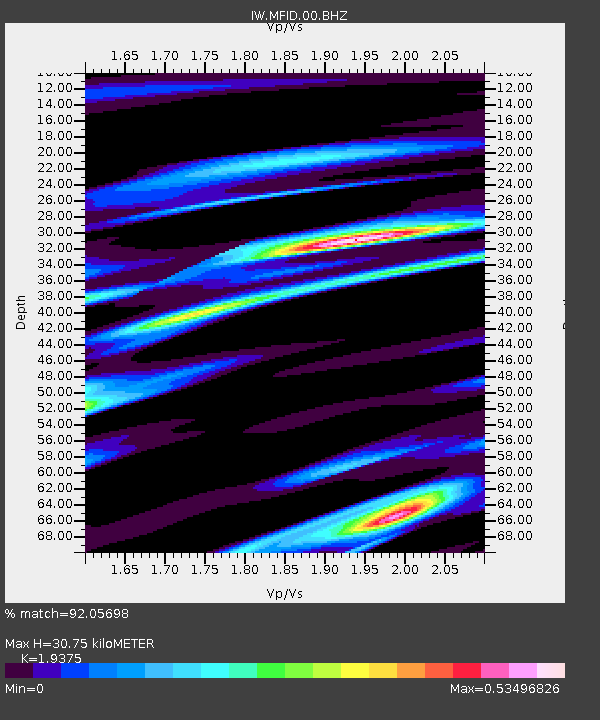
| Estimated Moho Depth: |
30.75 km |
| Estimated Crust Vp/Vs: |
1.94 |
| Assumed Crust Vp: |
6.291 km/s |
| Estimated Crust Vs: |
3.247 km/s |
| Estimated Crust Poisson's Ratio: |
0.32 |
|
| Radial Match: |
92.05698 % |
| Radial Bump: |
400 |
| Transverse Match: |
62.652493 % |
| Transverse Bump: |
400 |
| SOD ConfigId: |
2364251 |
| Insert Time: |
2017-10-09 17:11:14.253 +0000 |
| GWidth: |
2.5 |
| Max Bumps: |
400 |
| Tol: |
0.001 |
|

Signal To Noise
| Channel | StoN | STA | LTA |
| IW:MFID:00:BHZ:20170727T18:03:26.125022Z | 2.5128832 | 1.755667E-7 | 6.986663E-8 |
| IW:MFID:00:BH1:20170727T18:03:26.125022Z | 1.2657764 | 1.2307162E-7 | 9.7230135E-8 |
| IW:MFID:00:BH2:20170727T18:03:26.125022Z | 1.3567622 | 6.5465606E-8 | 4.825135E-8 |
| Arrivals |
| Ps | 4.8 SECOND |
| PpPs | 14 SECOND |
| PsPs/PpSs | 19 SECOND |


