You are here: Home > Network List > OX - North-East Italy Seismic Network Stations List
> Station PRED Cave del Predil > Earthquake Result Viewer
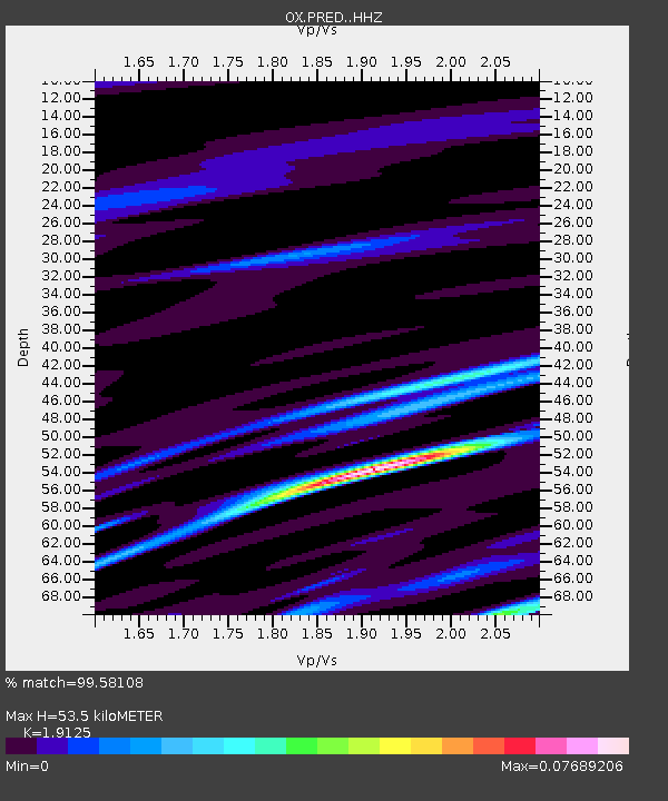
PRED Cave del Predil - Earthquake Result Viewer
| Earthquake location: |
Near East Coast Of Honshu, Japan |
| Earthquake latitude/longitude: |
40.8/142.5 |
| Earthquake time(UTC): |
2020/12/20 (355) 17:23:19 GMT |
| Earthquake Depth: |
10 km |
| Earthquake Magnitude: |
6.2 mww |
| Earthquake Catalog/Contributor: |
NEIC PDE/us |
|
| Network: |
OX North-East Italy Seismic Network |
| Station: |
PRED Cave del Predil |
| Lat/Lon: |
46.44 N/13.56 E |
| Elevation: |
902 m |
|
| Distance: |
81.9 deg |
| Az: |
327.113 deg |
| Baz: |
36.569 deg |
| Ray Param: |
0.047249194 |
| Estimated Moho Depth: |
53.5 km |
| Estimated Crust Vp/Vs: |
1.91 |
| Assumed Crust Vp: |
6.35 km/s |
| Estimated Crust Vs: |
3.32 km/s |
| Estimated Crust Poisson's Ratio: |
0.31 |
|
| Radial Match: |
99.58108 % |
| Radial Bump: |
69 |
| Transverse Match: |
67.92192 % |
| Transverse Bump: |
400 |
| SOD ConfigId: |
23341671 |
| Insert Time: |
2021-01-03 18:47:19.101 +0000 |
| GWidth: |
2.5 |
| Max Bumps: |
400 |
| Tol: |
0.001 |
|

Signal To Noise
| Channel | StoN | STA | LTA |
| OX:PRED: :HHZ:20201220T17:35:07.487976Z | 10.477572 | 1.0564789E-6 | 1.0083241E-7 |
| OX:PRED: :HHN:20201220T17:35:07.487976Z | 7.503331 | 6.759214E-7 | 9.008284E-8 |
| OX:PRED: :HHE:20201220T17:35:07.487976Z | 3.5852218 | 5.7327605E-7 | 1.5989974E-7 |
| Arrivals |
| Ps | 7.9 SECOND |
| PpPs | 24 SECOND |
| PsPs/PpSs | 32 SECOND |


