You are here: Home > Network List > TA - USArray Transportable Network (new EarthScope stations) Stations List
> Station F19K Shaleruckik Mountain, AK, USA > Earthquake Result Viewer
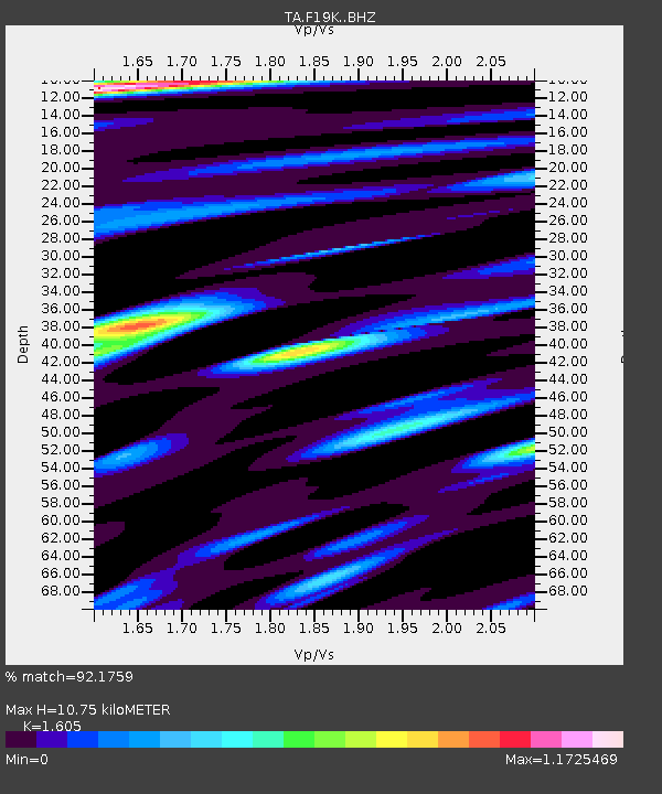
F19K Shaleruckik Mountain, AK, USA - Earthquake Result Viewer
| Earthquake location: |
Near East Coast Of Honshu, Japan |
| Earthquake latitude/longitude: |
40.8/142.5 |
| Earthquake time(UTC): |
2020/12/20 (355) 17:23:19 GMT |
| Earthquake Depth: |
10 km |
| Earthquake Magnitude: |
6.2 mww |
| Earthquake Catalog/Contributor: |
NEIC PDE/us |
|
| Network: |
TA USArray Transportable Network (new EarthScope stations) |
| Station: |
F19K Shaleruckik Mountain, AK, USA |
| Lat/Lon: |
66.83 N/157.77 W |
| Elevation: |
161 m |
|
| Distance: |
41.4 deg |
| Az: |
31.075 deg |
| Baz: |
261.834 deg |
| Ray Param: |
0.073797904 |
| Estimated Moho Depth: |
10.75 km |
| Estimated Crust Vp/Vs: |
1.61 |
| Assumed Crust Vp: |
6.577 km/s |
| Estimated Crust Vs: |
4.098 km/s |
| Estimated Crust Poisson's Ratio: |
0.18 |
|
| Radial Match: |
92.1759 % |
| Radial Bump: |
350 |
| Transverse Match: |
80.99041 % |
| Transverse Bump: |
400 |
| SOD ConfigId: |
23341671 |
| Insert Time: |
2021-01-03 18:49:56.463 +0000 |
| GWidth: |
2.5 |
| Max Bumps: |
400 |
| Tol: |
0.001 |
|

Signal To Noise
| Channel | StoN | STA | LTA |
| TA:F19K: :BHZ:20201220T17:30:35.024993Z | 8.559244 | 1.111821E-6 | 1.2989709E-7 |
| TA:F19K: :BHN:20201220T17:30:35.024993Z | 2.0295014 | 1.7940951E-7 | 8.840078E-8 |
| TA:F19K: :BHE:20201220T17:30:35.024993Z | 5.9570794 | 4.7575574E-7 | 7.986393E-8 |
| Arrivals |
| Ps | 1.1 SECOND |
| PpPs | 3.9 SECOND |
| PsPs/PpSs | 5.0 SECOND |


