You are here: Home > Network List > TA - USArray Transportable Network (new EarthScope stations) Stations List
> Station G31M Satah River, YT, CAN > Earthquake Result Viewer
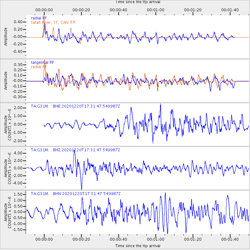
G31M Satah River, YT, CAN - Earthquake Result Viewer
*The percent match for this event was below the threshold and hence no stack was calculated.
| Earthquake location: |
Near East Coast Of Honshu, Japan |
| Earthquake latitude/longitude: |
40.8/142.5 |
| Earthquake time(UTC): |
2020/12/20 (355) 17:23:19 GMT |
| Earthquake Depth: |
10 km |
| Earthquake Magnitude: |
6.2 mww |
| Earthquake Catalog/Contributor: |
NEIC PDE/us |
|
| Network: |
TA USArray Transportable Network (new EarthScope stations) |
| Station: |
G31M Satah River, YT, CAN |
| Lat/Lon: |
66.92 N/134.27 W |
| Elevation: |
61 m |
|
| Distance: |
50.6 deg |
| Az: |
30.411 deg |
| Baz: |
283.011 deg |
| Ray Param: |
$rayparam |
*The percent match for this event was below the threshold and hence was not used in the summary stack. |
|
| Radial Match: |
71.13088 % |
| Radial Bump: |
400 |
| Transverse Match: |
67.74973 % |
| Transverse Bump: |
400 |
| SOD ConfigId: |
23341671 |
| Insert Time: |
2021-01-03 18:50:19.375 +0000 |
| GWidth: |
2.5 |
| Max Bumps: |
400 |
| Tol: |
0.001 |
|
Signal To Noise
| Channel | StoN | STA | LTA |
| TA:G31M: :BHZ:20201220T17:31:47.549987Z | 2.777164 | 9.752008E-7 | 3.5114985E-7 |
| TA:G31M: :BHN:20201220T17:31:47.549987Z | 0.9596517 | 3.1957265E-7 | 3.3300898E-7 |
| TA:G31M: :BHE:20201220T17:31:47.549987Z | 1.5914536 | 3.729637E-7 | 2.3435413E-7 |
| Arrivals |
| Ps | |
| PpPs | |
| PsPs/PpSs | |


