You are here: Home > Network List > TA - USArray Transportable Network (new EarthScope stations) Stations List
> Station H27K Steamboat Mountain, AK, USA > Earthquake Result Viewer
H27K Steamboat Mountain, AK, USA - Earthquake Result Viewer
| Earthquake location: |
Near East Coast Of Honshu, Japan |
| Earthquake latitude/longitude: |
40.8/142.5 |
| Earthquake time(UTC): |
2020/12/20 (355) 17:23:19 GMT |
| Earthquake Depth: |
10 km |
| Earthquake Magnitude: |
6.2 mww |
| Earthquake Catalog/Contributor: |
NEIC PDE/us |
|
| Network: |
TA USArray Transportable Network (new EarthScope stations) |
| Station: |
H27K Steamboat Mountain, AK, USA |
| Lat/Lon: |
66.23 N/141.53 W |
| Elevation: |
786 m |
|
| Distance: |
47.9 deg |
| Az: |
31.99 deg |
| Baz: |
277.388 deg |
| Ray Param: |
0.06970552 |
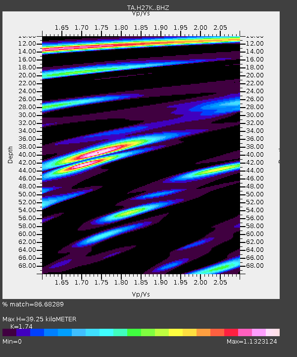
| Estimated Moho Depth: |
39.25 km |
| Estimated Crust Vp/Vs: |
1.74 |
| Assumed Crust Vp: |
6.577 km/s |
| Estimated Crust Vs: |
3.78 km/s |
| Estimated Crust Poisson's Ratio: |
0.25 |
|
| Radial Match: |
86.68289 % |
| Radial Bump: |
369 |
| Transverse Match: |
76.93451 % |
| Transverse Bump: |
295 |
| SOD ConfigId: |
23341671 |
| Insert Time: |
2021-01-03 18:50:25.232 +0000 |
| GWidth: |
2.5 |
| Max Bumps: |
400 |
| Tol: |
0.001 |
|

Signal To Noise
| Channel | StoN | STA | LTA |
| TA:H27K: :BHZ:20201220T17:31:26.700012Z | 3.4113097 | 9.094689E-7 | 2.6660402E-7 |
| TA:H27K: :BHN:20201220T17:31:26.700012Z | 0.6161992 | 1.9454316E-7 | 3.1571471E-7 |
| TA:H27K: :BHE:20201220T17:31:26.700012Z | 3.6762292 | 5.634203E-7 | 1.5326037E-7 |
| Arrivals |
| Ps | 4.7 SECOND |
| PpPs | 15 SECOND |
| PsPs/PpSs | 20 SECOND |


