You are here: Home > Network List > TX - Texas Seismological Network Stations List
> Station 833A Chaparral WMA, Artesia Wells, TX, USA > Earthquake Result Viewer
833A Chaparral WMA, Artesia Wells, TX, USA - Earthquake Result Viewer
| Earthquake location: |
Near East Coast Of Honshu, Japan |
| Earthquake latitude/longitude: |
40.8/142.5 |
| Earthquake time(UTC): |
2020/12/20 (355) 17:23:19 GMT |
| Earthquake Depth: |
10 km |
| Earthquake Magnitude: |
6.2 mww |
| Earthquake Catalog/Contributor: |
NEIC PDE/us |
|
| Network: |
TX Texas Seismological Network |
| Station: |
833A Chaparral WMA, Artesia Wells, TX, USA |
| Lat/Lon: |
28.32 N/99.39 W |
| Elevation: |
171 m |
|
| Distance: |
90.4 deg |
| Az: |
51.073 deg |
| Baz: |
317.968 deg |
| Ray Param: |
0.041705202 |
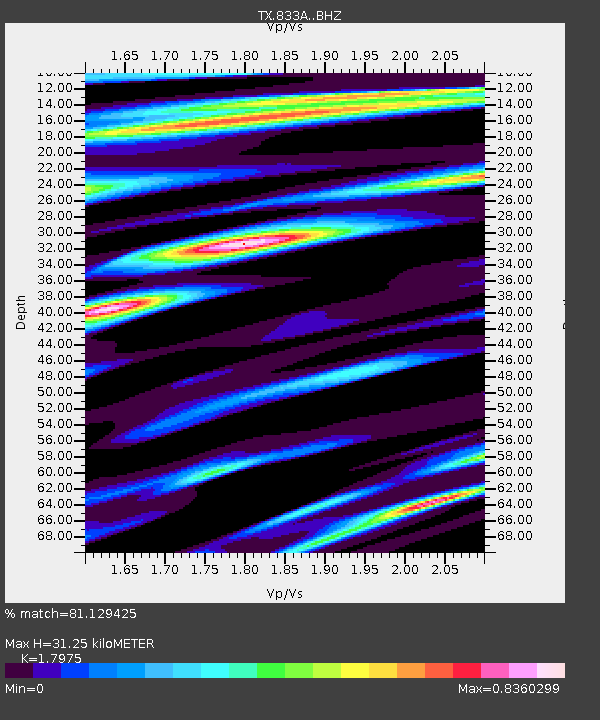
| Estimated Moho Depth: |
31.25 km |
| Estimated Crust Vp/Vs: |
1.80 |
| Assumed Crust Vp: |
6.347 km/s |
| Estimated Crust Vs: |
3.531 km/s |
| Estimated Crust Poisson's Ratio: |
0.28 |
|
| Radial Match: |
81.129425 % |
| Radial Bump: |
349 |
| Transverse Match: |
78.89166 % |
| Transverse Bump: |
383 |
| SOD ConfigId: |
23341671 |
| Insert Time: |
2021-01-03 18:51:07.992 +0000 |
| GWidth: |
2.5 |
| Max Bumps: |
400 |
| Tol: |
0.001 |
|

Signal To Noise
| Channel | StoN | STA | LTA |
| TX:833A: :BHZ:20201220T17:35:49.224975Z | 1.784707 | 2.717736E-7 | 1.5227911E-7 |
| TX:833A: :BHN:20201220T17:35:49.224975Z | 1.0489743 | 1.2941226E-7 | 1.2337028E-7 |
| TX:833A: :BHE:20201220T17:35:49.224975Z | 1.7576268 | 1.8143358E-7 | 1.03226455E-7 |
| Arrivals |
| Ps | 4.0 SECOND |
| PpPs | 14 SECOND |
| PsPs/PpSs | 18 SECOND |


