You are here: Home > Network List > TX - Texas Seismological Network Stations List
> Station WTFS Witchita Falls > Earthquake Result Viewer
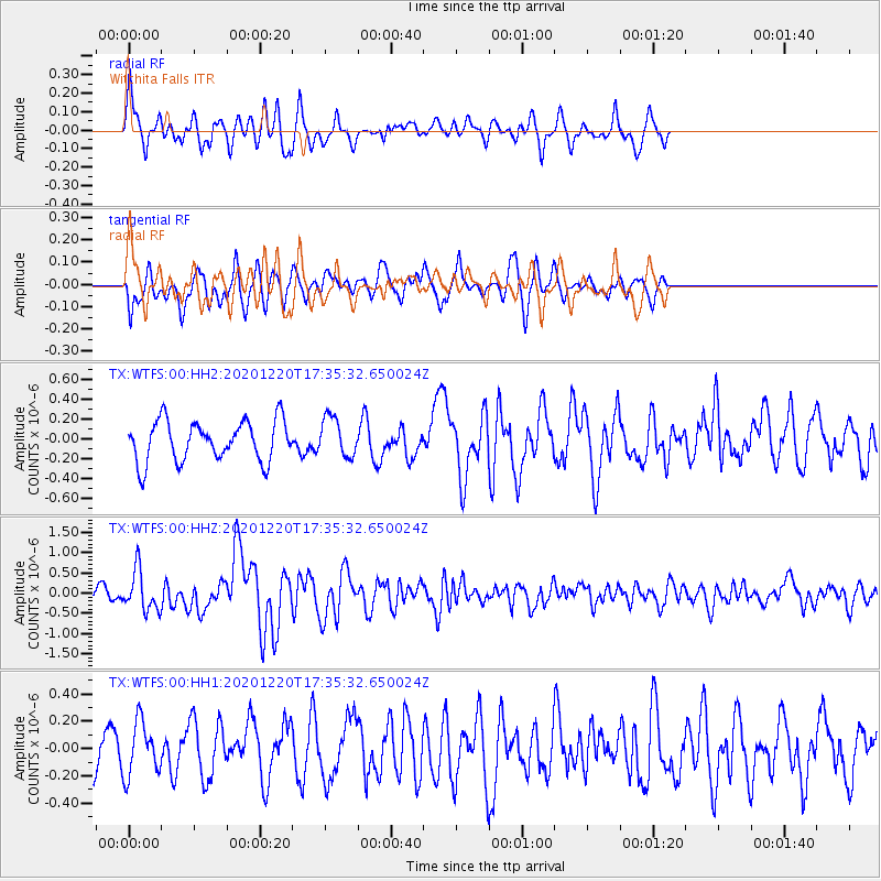
WTFS Witchita Falls - Earthquake Result Viewer
*The percent match for this event was below the threshold and hence no stack was calculated.
| Earthquake location: |
Near East Coast Of Honshu, Japan |
| Earthquake latitude/longitude: |
40.8/142.5 |
| Earthquake time(UTC): |
2020/12/20 (355) 17:23:19 GMT |
| Earthquake Depth: |
10 km |
| Earthquake Magnitude: |
6.2 mww |
| Earthquake Catalog/Contributor: |
NEIC PDE/us |
|
| Network: |
TX Texas Seismological Network |
| Station: |
WTFS Witchita Falls |
| Lat/Lon: |
33.77 N/98.46 W |
| Elevation: |
277 m |
|
| Distance: |
86.9 deg |
| Az: |
46.859 deg |
| Baz: |
318.347 deg |
| Ray Param: |
$rayparam |
*The percent match for this event was below the threshold and hence was not used in the summary stack. |
|
| Radial Match: |
58.958992 % |
| Radial Bump: |
400 |
| Transverse Match: |
58.162766 % |
| Transverse Bump: |
400 |
| SOD ConfigId: |
23341671 |
| Insert Time: |
2021-01-03 18:52:25.735 +0000 |
| GWidth: |
2.5 |
| Max Bumps: |
400 |
| Tol: |
0.001 |
|
Signal To Noise
| Channel | StoN | STA | LTA |
| TX:WTFS:00:HHZ:20201220T17:35:32.650024Z | 5.233169 | 4.909439E-7 | 9.3813874E-8 |
| TX:WTFS:00:HH1:20201220T17:35:32.650024Z | 1.4507148 | 1.9689146E-7 | 1.3572031E-7 |
| TX:WTFS:00:HH2:20201220T17:35:32.650024Z | 0.9655809 | 1.9844714E-7 | 2.05521E-7 |
| Arrivals |
| Ps | |
| PpPs | |
| PsPs/PpSs | |


