You are here: Home > Network List > US - United States National Seismic Network Stations List
> Station ERPA Erie, Pennsylvania, USA > Earthquake Result Viewer
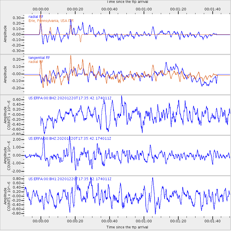
ERPA Erie, Pennsylvania, USA - Earthquake Result Viewer
*The percent match for this event was below the threshold and hence no stack was calculated.
| Earthquake location: |
Near East Coast Of Honshu, Japan |
| Earthquake latitude/longitude: |
40.8/142.5 |
| Earthquake time(UTC): |
2020/12/20 (355) 17:23:19 GMT |
| Earthquake Depth: |
10 km |
| Earthquake Magnitude: |
6.2 mww |
| Earthquake Catalog/Contributor: |
NEIC PDE/us |
|
| Network: |
US United States National Seismic Network |
| Station: |
ERPA Erie, Pennsylvania, USA |
| Lat/Lon: |
42.12 N/79.99 W |
| Elevation: |
306 m |
|
| Distance: |
88.9 deg |
| Az: |
30.199 deg |
| Baz: |
329.137 deg |
| Ray Param: |
$rayparam |
*The percent match for this event was below the threshold and hence was not used in the summary stack. |
|
| Radial Match: |
71.86367 % |
| Radial Bump: |
400 |
| Transverse Match: |
45.96846 % |
| Transverse Bump: |
400 |
| SOD ConfigId: |
23341671 |
| Insert Time: |
2021-01-03 18:53:09.304 +0000 |
| GWidth: |
2.5 |
| Max Bumps: |
400 |
| Tol: |
0.001 |
|
Signal To Noise
| Channel | StoN | STA | LTA |
| US:ERPA:00:BHZ:20201220T17:35:42.174011Z | 4.9972315 | 9.1128015E-7 | 1.82357E-7 |
| US:ERPA:00:BH1:20201220T17:35:42.174011Z | 0.9410477 | 2.1176608E-7 | 2.2503224E-7 |
| US:ERPA:00:BH2:20201220T17:35:42.174011Z | 0.86296266 | 1.934649E-7 | 2.2418686E-7 |
| Arrivals |
| Ps | |
| PpPs | |
| PsPs/PpSs | |


