You are here: Home > Network List > UU - University of Utah Regional Network Stations List
> Station KNB Kanab, UT, USA > Earthquake Result Viewer
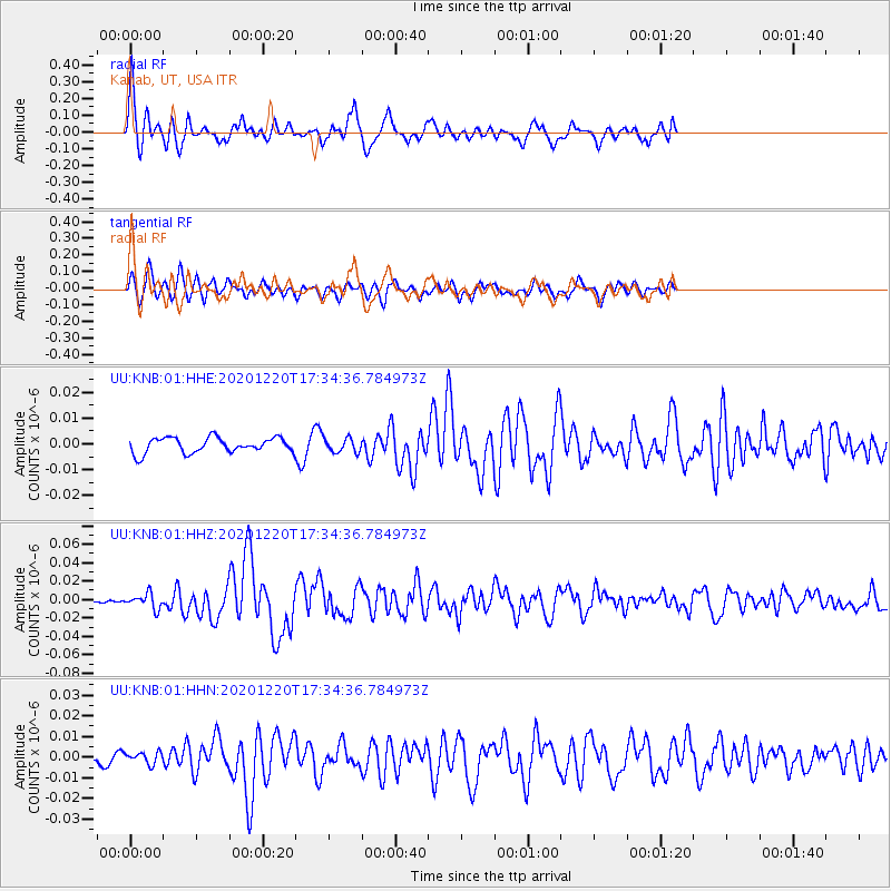
KNB Kanab, UT, USA - Earthquake Result Viewer
*The percent match for this event was below the threshold and hence no stack was calculated.
| Earthquake location: |
Near East Coast Of Honshu, Japan |
| Earthquake latitude/longitude: |
40.8/142.5 |
| Earthquake time(UTC): |
2020/12/20 (355) 17:23:19 GMT |
| Earthquake Depth: |
10 km |
| Earthquake Magnitude: |
6.2 mww |
| Earthquake Catalog/Contributor: |
NEIC PDE/us |
|
| Network: |
UU University of Utah Regional Network |
| Station: |
KNB Kanab, UT, USA |
| Lat/Lon: |
37.02 N/112.82 W |
| Elevation: |
1715 m |
|
| Distance: |
76.3 deg |
| Az: |
52.857 deg |
| Baz: |
310.917 deg |
| Ray Param: |
$rayparam |
*The percent match for this event was below the threshold and hence was not used in the summary stack. |
|
| Radial Match: |
78.48902 % |
| Radial Bump: |
400 |
| Transverse Match: |
62.9837 % |
| Transverse Bump: |
375 |
| SOD ConfigId: |
23341671 |
| Insert Time: |
2021-01-03 18:54:06.410 +0000 |
| GWidth: |
2.5 |
| Max Bumps: |
400 |
| Tol: |
0.001 |
|
Signal To Noise
| Channel | StoN | STA | LTA |
| UU:KNB:01:HHZ:20201220T17:34:36.784973Z | 1.9890014 | 8.187122E-9 | 4.116197E-9 |
| UU:KNB:01:HHN:20201220T17:34:36.784973Z | 0.74038905 | 2.8663205E-9 | 3.871371E-9 |
| UU:KNB:01:HHE:20201220T17:34:36.784973Z | 0.96416205 | 2.7965348E-9 | 2.900482E-9 |
| Arrivals |
| Ps | |
| PpPs | |
| PsPs/PpSs | |


