You are here: Home > Network List > GG - Greenland Ice Sheet Monitoring Network Stations List
> Station SE1 Kagssortoq, Greenland > Earthquake Result Viewer
SE1 Kagssortoq, Greenland - Earthquake Result Viewer
| Earthquake location: |
Northern Xinjiang, China |
| Earthquake latitude/longitude: |
44.3/82.8 |
| Earthquake time(UTC): |
2017/08/08 (220) 23:27:53 GMT |
| Earthquake Depth: |
20 km |
| Earthquake Magnitude: |
6.3 Mww |
| Earthquake Catalog/Contributor: |
NEIC PDE/us |
|
| Network: |
GG Greenland Ice Sheet Monitoring Network |
| Station: |
SE1 Kagssortoq, Greenland |
| Lat/Lon: |
63.25 N/42.03 W |
| Elevation: |
23 m |
|
| Distance: |
64.2 deg |
| Az: |
335.649 deg |
| Baz: |
40.857 deg |
| Ray Param: |
0.059042722 |
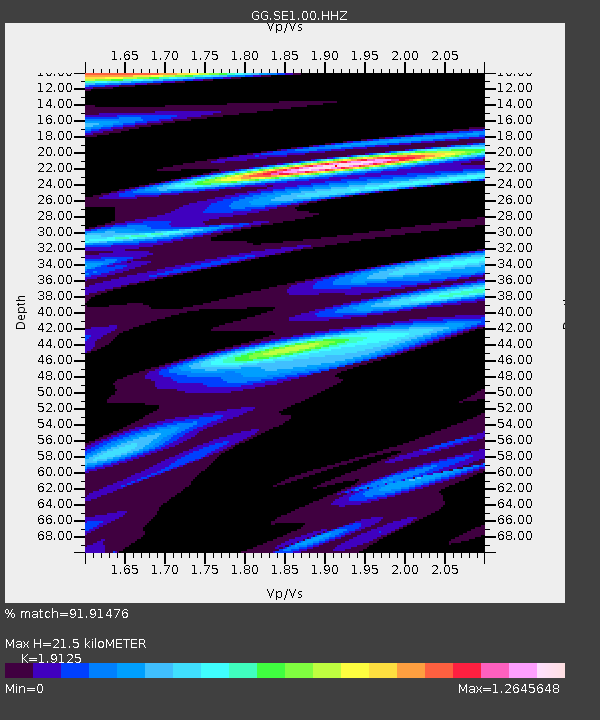
| Estimated Moho Depth: |
21.5 km |
| Estimated Crust Vp/Vs: |
1.91 |
| Assumed Crust Vp: |
6.424 km/s |
| Estimated Crust Vs: |
3.359 km/s |
| Estimated Crust Poisson's Ratio: |
0.31 |
|
| Radial Match: |
91.91476 % |
| Radial Bump: |
400 |
| Transverse Match: |
80.13624 % |
| Transverse Bump: |
400 |
| SOD ConfigId: |
2364251 |
| Insert Time: |
2017-10-09 17:58:32.545 +0000 |
| GWidth: |
2.5 |
| Max Bumps: |
400 |
| Tol: |
0.001 |
|
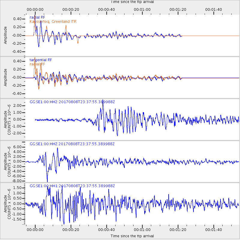
Signal To Noise
| Channel | StoN | STA | LTA |
| GG:SE1:00:HHZ:20170808T23:37:55.389988Z | 9.051059 | 1.051891E-6 | 1.1621745E-7 |
| GG:SE1:00:HH1:20170808T23:37:55.389988Z | 4.25405 | 3.866153E-7 | 9.088171E-8 |
| GG:SE1:00:HH2:20170808T23:37:55.389988Z | 4.5015297 | 3.5309674E-7 | 7.843928E-8 |
| Arrivals |
| Ps | 3.2 SECOND |
| PpPs | 9.4 SECOND |
| PsPs/PpSs | 13 SECOND |


