You are here: Home > Network List > US - United States National Seismic Network Stations List
> Station HDIL Hopedale, Illinois, USA > Earthquake Result Viewer
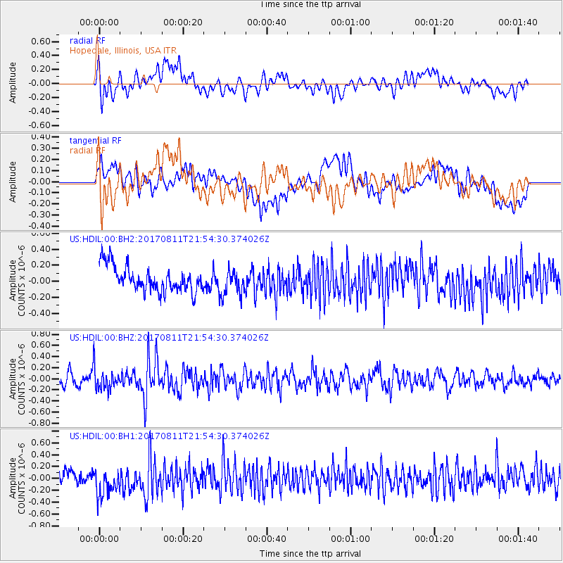
HDIL Hopedale, Illinois, USA - Earthquake Result Viewer
*The percent match for this event was below the threshold and hence no stack was calculated.
| Earthquake location: |
Near Coast Of Peru |
| Earthquake latitude/longitude: |
-16.3/-73.5 |
| Earthquake time(UTC): |
2017/08/11 (223) 21:45:09 GMT |
| Earthquake Depth: |
35 km |
| Earthquake Magnitude: |
5.6 Mww |
| Earthquake Catalog/Contributor: |
NEIC PDE/us |
|
| Network: |
US United States National Seismic Network |
| Station: |
HDIL Hopedale, Illinois, USA |
| Lat/Lon: |
40.56 N/89.29 W |
| Elevation: |
219 m |
|
| Distance: |
58.4 deg |
| Az: |
345.897 deg |
| Baz: |
162.115 deg |
| Ray Param: |
$rayparam |
*The percent match for this event was below the threshold and hence was not used in the summary stack. |
|
| Radial Match: |
45.53244 % |
| Radial Bump: |
400 |
| Transverse Match: |
33.766678 % |
| Transverse Bump: |
400 |
| SOD ConfigId: |
2364251 |
| Insert Time: |
2017-10-09 18:07:20.823 +0000 |
| GWidth: |
2.5 |
| Max Bumps: |
400 |
| Tol: |
0.001 |
|
Signal To Noise
| Channel | StoN | STA | LTA |
| US:HDIL:00:BHZ:20170811T21:54:30.374026Z | 1.5889066 | 1.411408E-7 | 8.8828884E-8 |
| US:HDIL:00:BH1:20170811T21:54:30.374026Z | 1.4118037 | 2.3414198E-7 | 1.6584599E-7 |
| US:HDIL:00:BH2:20170811T21:54:30.374026Z | 0.9883816 | 1.5496512E-7 | 1.5678674E-7 |
| Arrivals |
| Ps | |
| PpPs | |
| PsPs/PpSs | |


