You are here: Home > Network List > AU - Australian Seismological Centre Stations List
> Station DNDOZ Balladonia, WA > Earthquake Result Viewer
DNDOZ Balladonia, WA - Earthquake Result Viewer
| Earthquake location: |
W. Caroline Islands, Micronesia |
| Earthquake latitude/longitude: |
6.3/133.6 |
| Earthquake time(UTC): |
2020/12/23 (358) 18:11:47 GMT |
| Earthquake Depth: |
10 km |
| Earthquake Magnitude: |
5.9 mww |
| Earthquake Catalog/Contributor: |
NEIC PDE/us |
|
| Network: |
AU Australian Seismological Centre |
| Station: |
DNDOZ Balladonia, WA |
| Lat/Lon: |
32.46 S/123.87 E |
| Elevation: |
153 m |
|
| Distance: |
39.6 deg |
| Az: |
192.995 deg |
| Baz: |
15.332 deg |
| Ray Param: |
0.074879594 |
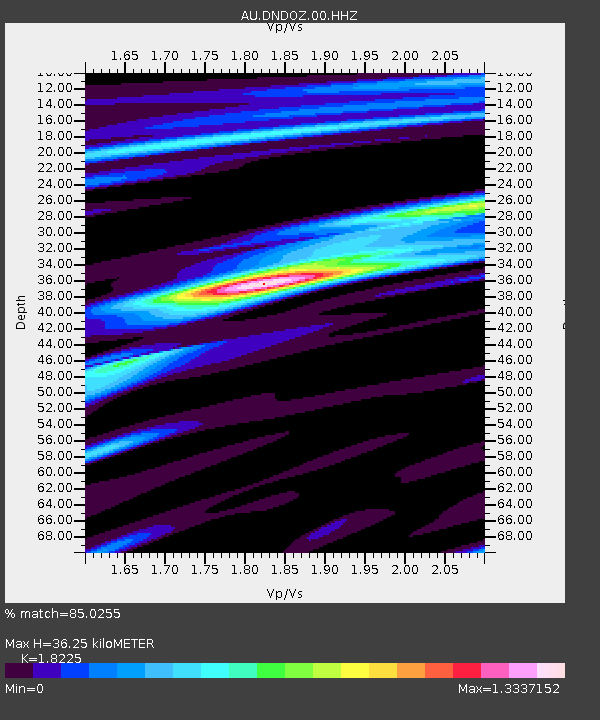
| Estimated Moho Depth: |
36.25 km |
| Estimated Crust Vp/Vs: |
1.82 |
| Assumed Crust Vp: |
6.464 km/s |
| Estimated Crust Vs: |
3.547 km/s |
| Estimated Crust Poisson's Ratio: |
0.28 |
|
| Radial Match: |
85.0255 % |
| Radial Bump: |
282 |
| Transverse Match: |
84.18661 % |
| Transverse Bump: |
307 |
| SOD ConfigId: |
23341671 |
| Insert Time: |
2021-01-06 19:14:28.010 +0000 |
| GWidth: |
2.5 |
| Max Bumps: |
400 |
| Tol: |
0.001 |
|

Signal To Noise
| Channel | StoN | STA | LTA |
| AU:DNDOZ:00:HHZ:20201223T18:18:48.530014Z | 9.929702 | 1.0133096E-5 | 1.0204834E-6 |
| AU:DNDOZ:00:HHN:20201223T18:18:48.530014Z | 9.570352 | 5.7690972E-6 | 6.0280934E-7 |
| AU:DNDOZ:00:HHE:20201223T18:18:48.530014Z | 1.454353 | 9.914191E-8 | 6.816908E-8 |
| Arrivals |
| Ps | 4.9 SECOND |
| PpPs | 15 SECOND |
| PsPs/PpSs | 20 SECOND |


