You are here: Home > Network List > IU - Global Seismograph Network (GSN - IRIS/USGS) Stations List
> Station JOHN Johnston Island, USA > Earthquake Result Viewer
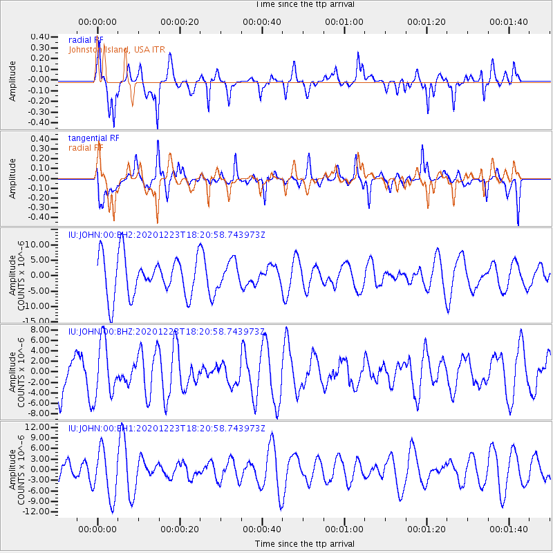
JOHN Johnston Island, USA - Earthquake Result Viewer
*The percent match for this event was below the threshold and hence no stack was calculated.
| Earthquake location: |
W. Caroline Islands, Micronesia |
| Earthquake latitude/longitude: |
6.3/133.6 |
| Earthquake time(UTC): |
2020/12/23 (358) 18:11:47 GMT |
| Earthquake Depth: |
10 km |
| Earthquake Magnitude: |
5.9 mww |
| Earthquake Catalog/Contributor: |
NEIC PDE/us |
|
| Network: |
IU Global Seismograph Network (GSN - IRIS/USGS) |
| Station: |
JOHN Johnston Island, USA |
| Lat/Lon: |
16.73 N/169.53 W |
| Elevation: |
2.0 m |
|
| Distance: |
56.5 deg |
| Az: |
74.16 deg |
| Baz: |
266.449 deg |
| Ray Param: |
$rayparam |
*The percent match for this event was below the threshold and hence was not used in the summary stack. |
|
| Radial Match: |
62.226463 % |
| Radial Bump: |
400 |
| Transverse Match: |
62.17714 % |
| Transverse Bump: |
400 |
| SOD ConfigId: |
23341671 |
| Insert Time: |
2021-01-06 19:18:05.531 +0000 |
| GWidth: |
2.5 |
| Max Bumps: |
400 |
| Tol: |
0.001 |
|
Signal To Noise
| Channel | StoN | STA | LTA |
| IU:JOHN:00:BHZ:20201223T18:20:58.743973Z | 1.7817389 | 5.2107484E-6 | 2.9245298E-6 |
| IU:JOHN:00:BH1:20201223T18:20:58.743973Z | 2.9929762 | 6.9686466E-6 | 2.3283335E-6 |
| IU:JOHN:00:BH2:20201223T18:20:58.743973Z | 0.6194809 | 4.061187E-6 | 6.5557906E-6 |
| Arrivals |
| Ps | |
| PpPs | |
| PsPs/PpSs | |


