You are here: Home > Network List > KR - Kyrgyz Digital Network Stations List
> Station BOOM Boom, Kyrgyzstan > Earthquake Result Viewer
BOOM Boom, Kyrgyzstan - Earthquake Result Viewer
| Earthquake location: |
W. Caroline Islands, Micronesia |
| Earthquake latitude/longitude: |
6.3/133.6 |
| Earthquake time(UTC): |
2020/12/23 (358) 18:11:47 GMT |
| Earthquake Depth: |
10 km |
| Earthquake Magnitude: |
5.9 mww |
| Earthquake Catalog/Contributor: |
NEIC PDE/us |
|
| Network: |
KR Kyrgyz Digital Network |
| Station: |
BOOM Boom, Kyrgyzstan |
| Lat/Lon: |
42.49 N/75.94 E |
| Elevation: |
1737 m |
|
| Distance: |
62.2 deg |
| Az: |
315.045 deg |
| Baz: |
108.265 deg |
| Ray Param: |
0.060370672 |
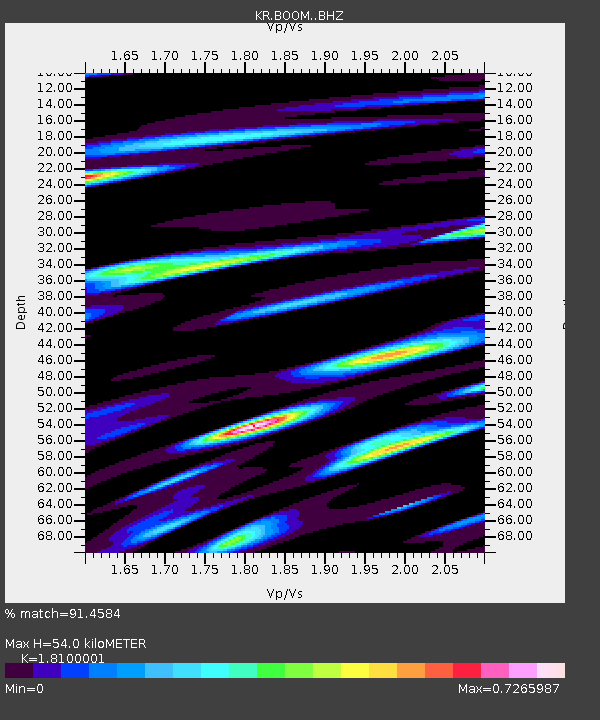
| Estimated Moho Depth: |
54.0 km |
| Estimated Crust Vp/Vs: |
1.81 |
| Assumed Crust Vp: |
6.306 km/s |
| Estimated Crust Vs: |
3.484 km/s |
| Estimated Crust Poisson's Ratio: |
0.28 |
|
| Radial Match: |
91.4584 % |
| Radial Bump: |
400 |
| Transverse Match: |
74.33797 % |
| Transverse Bump: |
400 |
| SOD ConfigId: |
23341671 |
| Insert Time: |
2021-01-06 19:18:40.543 +0000 |
| GWidth: |
2.5 |
| Max Bumps: |
400 |
| Tol: |
0.001 |
|
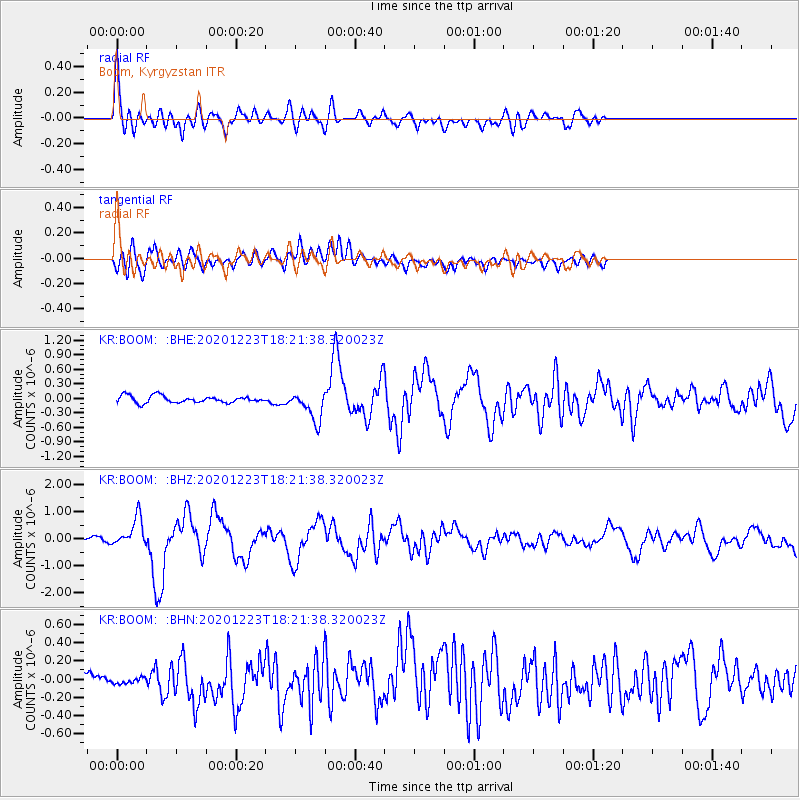
Signal To Noise
| Channel | StoN | STA | LTA |
| KR:BOOM: :BHZ:20201223T18:21:38.320023Z | 7.1029787 | 5.3447485E-7 | 7.524658E-8 |
| KR:BOOM: :BHN:20201223T18:21:38.320023Z | 0.44392234 | 3.6468577E-8 | 8.2150805E-8 |
| KR:BOOM: :BHE:20201223T18:21:38.320023Z | 4.269585 | 3.0584877E-7 | 7.1634304E-8 |
| Arrivals |
| Ps | 7.2 SECOND |
| PpPs | 23 SECOND |
| PsPs/PpSs | 30 SECOND |


