You are here: Home > Network List > TA - USArray Transportable Network (new EarthScope stations) Stations List
> Station R31K City Hall, Gustavus, AK, USA > Earthquake Result Viewer
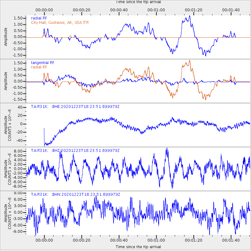
R31K City Hall, Gustavus, AK, USA - Earthquake Result Viewer
*The percent match for this event was below the threshold and hence no stack was calculated.
| Earthquake location: |
W. Caroline Islands, Micronesia |
| Earthquake latitude/longitude: |
6.3/133.6 |
| Earthquake time(UTC): |
2020/12/23 (358) 18:11:47 GMT |
| Earthquake Depth: |
10 km |
| Earthquake Magnitude: |
5.9 mww |
| Earthquake Catalog/Contributor: |
NEIC PDE/us |
|
| Network: |
TA USArray Transportable Network (new EarthScope stations) |
| Station: |
R31K City Hall, Gustavus, AK, USA |
| Lat/Lon: |
58.41 N/135.74 W |
| Elevation: |
15 m |
|
| Distance: |
85.0 deg |
| Az: |
31.89 deg |
| Baz: |
273.818 deg |
| Ray Param: |
$rayparam |
*The percent match for this event was below the threshold and hence was not used in the summary stack. |
|
| Radial Match: |
25.015316 % |
| Radial Bump: |
400 |
| Transverse Match: |
43.408623 % |
| Transverse Bump: |
400 |
| SOD ConfigId: |
23341671 |
| Insert Time: |
2021-01-06 19:21:08.073 +0000 |
| GWidth: |
2.5 |
| Max Bumps: |
400 |
| Tol: |
0.001 |
|
Signal To Noise
| Channel | StoN | STA | LTA |
| TA:R31K: :BHZ:20201223T18:23:51.899979Z | 0.84062195 | 1.9690624E-6 | 2.3423877E-6 |
| TA:R31K: :BHN:20201223T18:23:51.899979Z | 0.78068715 | 3.8535077E-6 | 4.936046E-6 |
| TA:R31K: :BHE:20201223T18:23:51.899979Z | 0.9281613 | 1.973657E-5 | 2.126416E-5 |
| Arrivals |
| Ps | |
| PpPs | |
| PsPs/PpSs | |


