You are here: Home > Network List > IC - New China Digital Seismograph Network Stations List
> Station WMQ Urumqi, Xinjiang Province, China > Earthquake Result Viewer
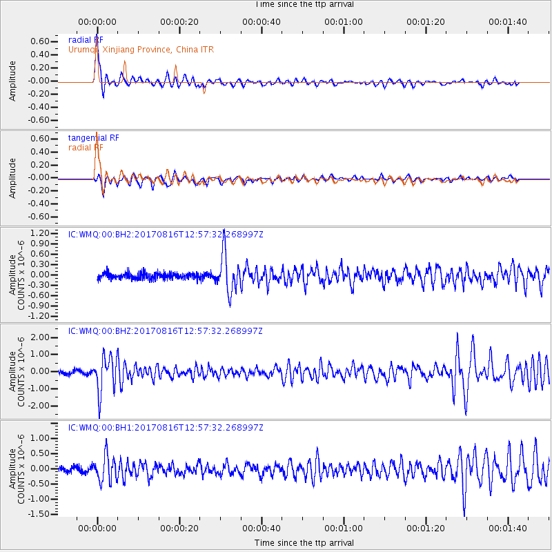
WMQ Urumqi, Xinjiang Province, China - Earthquake Result Viewer
*The percent match for this event was below the threshold and hence no stack was calculated.
| Earthquake location: |
Northwest Of Ryukyu Islands |
| Earthquake latitude/longitude: |
28.6/127.9 |
| Earthquake time(UTC): |
2017/08/16 (228) 12:51:25 GMT |
| Earthquake Depth: |
197 km |
| Earthquake Magnitude: |
5.7 Mww |
| Earthquake Catalog/Contributor: |
NEIC PDE/us |
|
| Network: |
IC New China Digital Seismograph Network |
| Station: |
WMQ Urumqi, Xinjiang Province, China |
| Lat/Lon: |
43.81 N/87.70 E |
| Elevation: |
850 m |
|
| Distance: |
35.4 deg |
| Az: |
306.249 deg |
| Baz: |
101.721 deg |
| Ray Param: |
$rayparam |
*The percent match for this event was below the threshold and hence was not used in the summary stack. |
|
| Radial Match: |
79.74116 % |
| Radial Bump: |
400 |
| Transverse Match: |
70.28782 % |
| Transverse Bump: |
384 |
| SOD ConfigId: |
2364251 |
| Insert Time: |
2017-10-09 18:44:00.703 +0000 |
| GWidth: |
2.5 |
| Max Bumps: |
400 |
| Tol: |
0.001 |
|
Signal To Noise
| Channel | StoN | STA | LTA |
| IC:WMQ:00:BHZ:20170816T12:57:32.268997Z | 9.878937 | 1.0556469E-6 | 1.06858344E-7 |
| IC:WMQ:00:BH1:20170816T12:57:32.268997Z | 4.6181226 | 4.3085495E-7 | 9.3296556E-8 |
| IC:WMQ:00:BH2:20170816T12:57:32.268997Z | 6.4971185 | 5.671347E-7 | 8.729019E-8 |
| Arrivals |
| Ps | |
| PpPs | |
| PsPs/PpSs | |


