You are here: Home > Network List > XW97 - Tien Shan Continental Dynamics Stations List
> Station AKSU XW.AKSU > Earthquake Result Viewer
AKSU XW.AKSU - Earthquake Result Viewer
| Earthquake location: |
Southern Sumatra, Indonesia |
| Earthquake latitude/longitude: |
-4.1/102.4 |
| Earthquake time(UTC): |
2000/07/22 (204) 20:56:12 GMT |
| Earthquake Depth: |
69 km |
| Earthquake Magnitude: |
5.8 MB, 5.8 MW, 5.7 MW |
| Earthquake Catalog/Contributor: |
WHDF/NEIC |
|
| Network: |
XW Tien Shan Continental Dynamics |
| Station: |
AKSU XW.AKSU |
| Lat/Lon: |
41.14 N/80.11 E |
| Elevation: |
1109 m |
|
| Distance: |
49.4 deg |
| Az: |
337.858 deg |
| Baz: |
150.145 deg |
| Ray Param: |
0.06853629 |
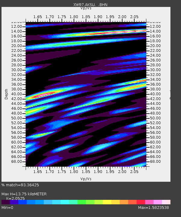
| Estimated Moho Depth: |
13.75 km |
| Estimated Crust Vp/Vs: |
2.05 |
| Assumed Crust Vp: |
6.129 km/s |
| Estimated Crust Vs: |
2.986 km/s |
| Estimated Crust Poisson's Ratio: |
0.34 |
|
| Radial Match: |
93.36425 % |
| Radial Bump: |
400 |
| Transverse Match: |
84.48087 % |
| Transverse Bump: |
400 |
| SOD ConfigId: |
20082 |
| Insert Time: |
2010-02-26 15:13:26.683 +0000 |
| GWidth: |
2.5 |
| Max Bumps: |
400 |
| Tol: |
0.001 |
|

Signal To Noise
| Channel | StoN | STA | LTA |
| XW:AKSU: :BHN:20000722T21:04:24.248013Z | 23.174116 | 6.5170667E-7 | 2.812218E-8 |
| XW:AKSU: :BHE:20000722T21:04:24.248013Z | 17.232729 | 3.9626994E-7 | 2.2995193E-8 |
| XW:AKSU: :BHZ:20000722T21:04:24.248013Z | 46.211414 | 1.4568394E-6 | 3.1525534E-8 |
| Arrivals |
| Ps | 2.5 SECOND |
| PpPs | 6.5 SECOND |
| PsPs/PpSs | 9.0 SECOND |


