You are here: Home > Network List > IU - Global Seismograph Network (GSN - IRIS/USGS) Stations List
> Station KMBO Kilima Mbogo, Kenya > Earthquake Result Viewer
KMBO Kilima Mbogo, Kenya - Earthquake Result Viewer

| Earthquake location: |
Mindoro, Philippines |
| Earthquake latitude/longitude: |
13.8/120.6 |
| Earthquake time(UTC): |
2020/12/24 (359) 23:43:42 GMT |
| Earthquake Depth: |
114 km |
| Earthquake Magnitude: |
6.3 Mww |
| Earthquake Catalog/Contributor: |
NEIC PDE/us |
|
| Network: |
IU Global Seismograph Network (GSN - IRIS/USGS) |
| Station: |
KMBO Kilima Mbogo, Kenya |
| Lat/Lon: |
1.13 S/37.25 E |
| Elevation: |
1950 m |
|
| Distance: |
83.9 deg |
| Az: |
267.332 deg |
| Baz: |
76.065 deg |
| Ray Param: |
0.04564706 |
| Estimated Moho Depth: |
41.5 km |
| Estimated Crust Vp/Vs: |
1.77 |
| Assumed Crust Vp: |
6.601 km/s |
| Estimated Crust Vs: |
3.719 km/s |
| Estimated Crust Poisson's Ratio: |
0.27 |
|
| Radial Match: |
96.83548 % |
| Radial Bump: |
323 |
| Transverse Match: |
96.19075 % |
| Transverse Bump: |
332 |
| SOD ConfigId: |
23341671 |
| Insert Time: |
2021-01-08 00:54:35.351 +0000 |
| GWidth: |
2.5 |
| Max Bumps: |
400 |
| Tol: |
0.001 |
|
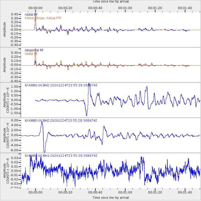
Signal To Noise
| Channel | StoN | STA | LTA |
| IU:KMBO:00:BHZ:20201224T23:55:28.368974Z | 26.536238 | 2.3220296E-6 | 8.75041E-8 |
| IU:KMBO:00:BH1:20201224T23:55:28.368974Z | 2.9807746 | 2.864503E-8 | 9.609928E-9 |
| IU:KMBO:00:BH2:20201224T23:55:28.368974Z | 13.007582 | 7.0519945E-7 | 5.4214492E-8 |
| Arrivals |
| Ps | 5.0 SECOND |
| PpPs | 17 SECOND |
| PsPs/PpSs | 22 SECOND |


