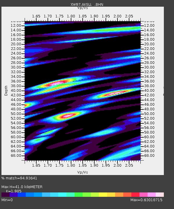
AKSU XW.AKSU - Earthquake Result Viewer
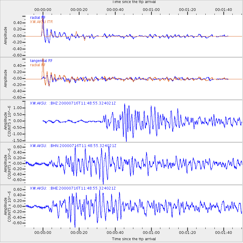
Earthquake location: Irian Jaya, Indonesia
Earthquake latitude/longitude: -4.2/138.9
Earthquake time(UTC): 2000/07/16 (198) 11:38:18 GMT
Earthquake Depth: 33 km
Earthquake Magnitude: 5.5 MB, 5.4 MS, 5.8 MW, 5.7 MW
Earthquake Catalog/Contributor: WHDF/NEIC
Network: XW Tien Shan Continental Dynamics
Station: AKSU XW.AKSU
Lat/Lon: 41.14 N/80.11 E
Elevation: 1109 m
Distance: 70.0 deg
Az: 316.557 deg
Baz: 114.76 deg
Ray Param: 0.055245418
Estimated Moho Depth: 41.0 km
Estimated Crust Vp/Vs: 1.99
Assumed Crust Vp: 6.129 km/s
Estimated Crust Vs: 3.088 km/s
Estimated Crust Poisson's Ratio: 0.33
Radial Match: 94.93641 %
Radial Bump: 328
Transverse Match: 88.21004 %
Transverse Bump: 400
SOD ConfigId: 20082
Insert Time: 2010-02-26 15:13:31.510 +0000
GWidth: 2.5
Max Bumps: 400
Tol: 0.001

Signal To Noise

ChannelStoNSTALTA
XW:AKSU: :BHN:20000716T11:48:55.324021Z1.32948964.4658474E-83.359069E-8
XW:AKSU: :BHE:20000716T11:48:55.324021Z2.2708817.1001566E-83.126609E-8
XW:AKSU: :BHZ:20000716T11:48:55.324021Z2.87592271.5997578E-75.5625897E-8
Arrivals
Ps6.8 SECOND
PpPs19 SECOND
PsPs/PpSs26 SECOND