You are here: Home > Network List > TA - USArray Transportable Network (new EarthScope stations) Stations List
> Station F14K Arctic Creek, AK, USA > Earthquake Result Viewer
F14K Arctic Creek, AK, USA - Earthquake Result Viewer
| Earthquake location: |
Mindoro, Philippines |
| Earthquake latitude/longitude: |
13.8/120.6 |
| Earthquake time(UTC): |
2020/12/24 (359) 23:43:42 GMT |
| Earthquake Depth: |
114 km |
| Earthquake Magnitude: |
6.3 Mww |
| Earthquake Catalog/Contributor: |
NEIC PDE/us |
|
| Network: |
TA USArray Transportable Network (new EarthScope stations) |
| Station: |
F14K Arctic Creek, AK, USA |
| Lat/Lon: |
65.47 N/166.33 W |
| Elevation: |
266 m |
|
| Distance: |
70.5 deg |
| Az: |
25.059 deg |
| Baz: |
260.309 deg |
| Ray Param: |
0.05466628 |
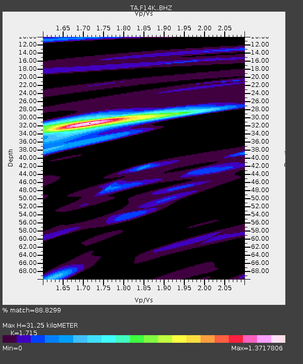
| Estimated Moho Depth: |
31.25 km |
| Estimated Crust Vp/Vs: |
1.72 |
| Assumed Crust Vp: |
6.307 km/s |
| Estimated Crust Vs: |
3.677 km/s |
| Estimated Crust Poisson's Ratio: |
0.24 |
|
| Radial Match: |
88.8299 % |
| Radial Bump: |
400 |
| Transverse Match: |
75.43207 % |
| Transverse Bump: |
400 |
| SOD ConfigId: |
23341671 |
| Insert Time: |
2021-01-08 00:57:35.551 +0000 |
| GWidth: |
2.5 |
| Max Bumps: |
400 |
| Tol: |
0.001 |
|
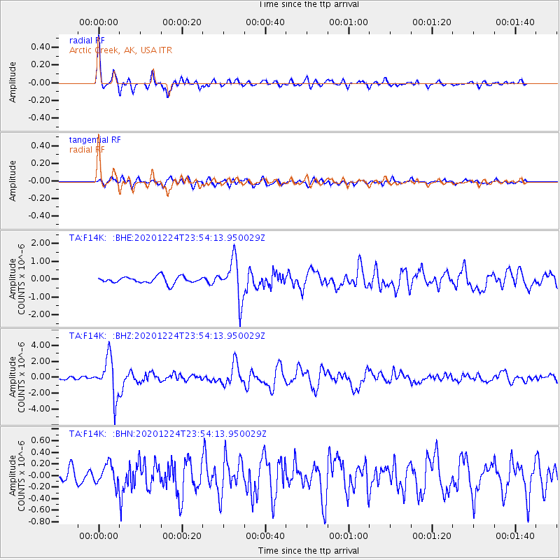
Signal To Noise
| Channel | StoN | STA | LTA |
| TA:F14K: :BHZ:20201224T23:54:13.950029Z | 12.8997755 | 2.542589E-6 | 1.9710336E-7 |
| TA:F14K: :BHN:20201224T23:54:13.950029Z | 1.6054411 | 1.7874832E-7 | 1.1133908E-7 |
| TA:F14K: :BHE:20201224T23:54:13.950029Z | 6.2484827 | 1.1623478E-6 | 1.860208E-7 |
| Arrivals |
| Ps | 3.7 SECOND |
| PpPs | 13 SECOND |
| PsPs/PpSs | 17 SECOND |


