You are here: Home > Network List > TA - USArray Transportable Network (new EarthScope stations) Stations List
> Station H31M Peel River, Yukon, CAN > Earthquake Result Viewer
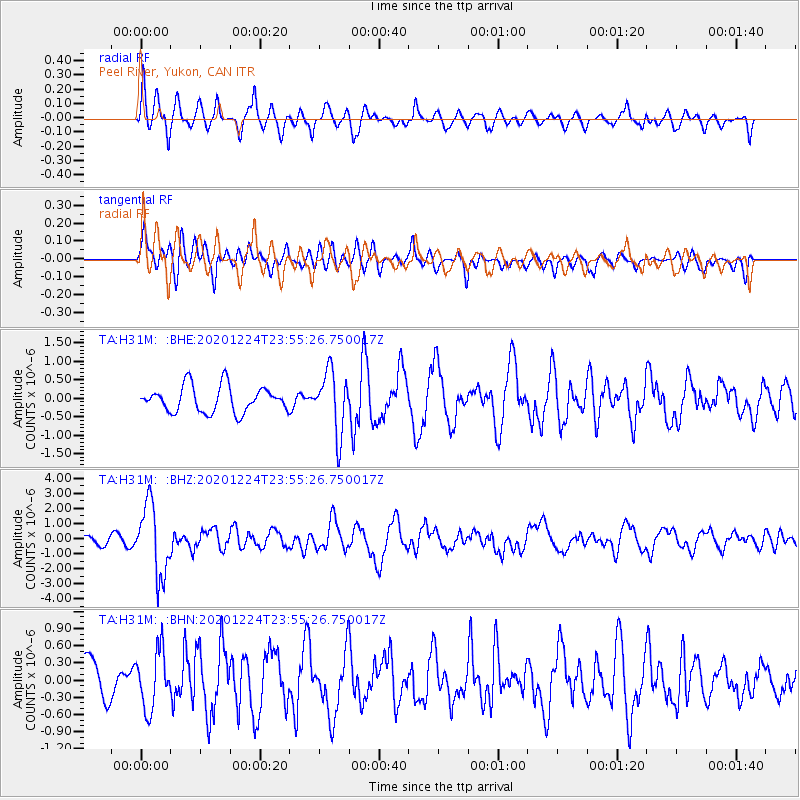
H31M Peel River, Yukon, CAN - Earthquake Result Viewer
*The percent match for this event was below the threshold and hence no stack was calculated.
| Earthquake location: |
Mindoro, Philippines |
| Earthquake latitude/longitude: |
13.8/120.6 |
| Earthquake time(UTC): |
2020/12/24 (359) 23:43:42 GMT |
| Earthquake Depth: |
114 km |
| Earthquake Magnitude: |
6.3 Mww |
| Earthquake Catalog/Contributor: |
NEIC PDE/us |
|
| Network: |
TA USArray Transportable Network (new EarthScope stations) |
| Station: |
H31M Peel River, Yukon, CAN |
| Lat/Lon: |
65.81 N/134.34 W |
| Elevation: |
642 m |
|
| Distance: |
83.5 deg |
| Az: |
23.617 deg |
| Baz: |
289.217 deg |
| Ray Param: |
$rayparam |
*The percent match for this event was below the threshold and hence was not used in the summary stack. |
|
| Radial Match: |
63.437614 % |
| Radial Bump: |
400 |
| Transverse Match: |
59.175648 % |
| Transverse Bump: |
400 |
| SOD ConfigId: |
23341671 |
| Insert Time: |
2021-01-08 00:58:08.507 +0000 |
| GWidth: |
2.5 |
| Max Bumps: |
400 |
| Tol: |
0.001 |
|
Signal To Noise
| Channel | StoN | STA | LTA |
| TA:H31M: :BHZ:20201224T23:55:26.750017Z | 6.79803 | 2.3438408E-6 | 3.447824E-7 |
| TA:H31M: :BHN:20201224T23:55:26.750017Z | 1.2189873 | 5.0076966E-7 | 4.1080793E-7 |
| TA:H31M: :BHE:20201224T23:55:26.750017Z | 2.3620758 | 8.292553E-7 | 3.5107058E-7 |
| Arrivals |
| Ps | |
| PpPs | |
| PsPs/PpSs | |


